What Are The US Territories?
- There are 14 US Territories scattered throughout the Caribbean Sea and Pacific Ocean.
- Puerto Rico is the most populous of the US Territories.
- Puerto Rico voted in favor of full US statehood in a non-binding referendum in the US elections of 2020.
- Residents of all the US Territories with permanent populations, except American Samoa, are American citizens.
The makeup of the United States of America includes 50 states, alongside the District of Columbia, housing the nation's capital, Washington. Yet, a lesser-known fact is the US's authority over regions not aligned with any state or the District of Columbia. These regions, termed US territories, are situated across the Caribbean Sea and the Pacific Ocean. While some harbor permanent populations, others remain uninhabited. Interestingly, many states within the US once occupied the same status as today's US territories.
The US Territories are:
- Puerto Rico
- Guam
- US Virgin Islands
- Northern Mariana Islands
- American Samoa
- Midway Atoll
- Palmyra Atoll
- Baker Island
- Howland Island
- Jarvis Island
- Johnston Atoll
- Kingman Reef
- Wake Island
- Navassa Island
Incorporated/Unincorporated Territories, Organized/Unorganized Territories
The territories are categorized into two groups: incorporated and unincorporated. Only one territory, Palmyra Atoll, is officially recognized as an incorporated territory, indicating that the full extent of the US Constitution applies within its borders. Conversely, all other territories are classified as unincorporated, meaning that only certain provisions of the Constitution are applicable. Notably, unincorporated territories lack the right to full representation in the US Congress.
Additionally, territories are distinguished based on their organization status. With the exception of American Samoa, all territories with permanent populations are considered organized, entailing that the US government has granted them a degree of self-governance with limited autonomy. Conversely, unorganized territories are those without permanent populations.
The US Territories
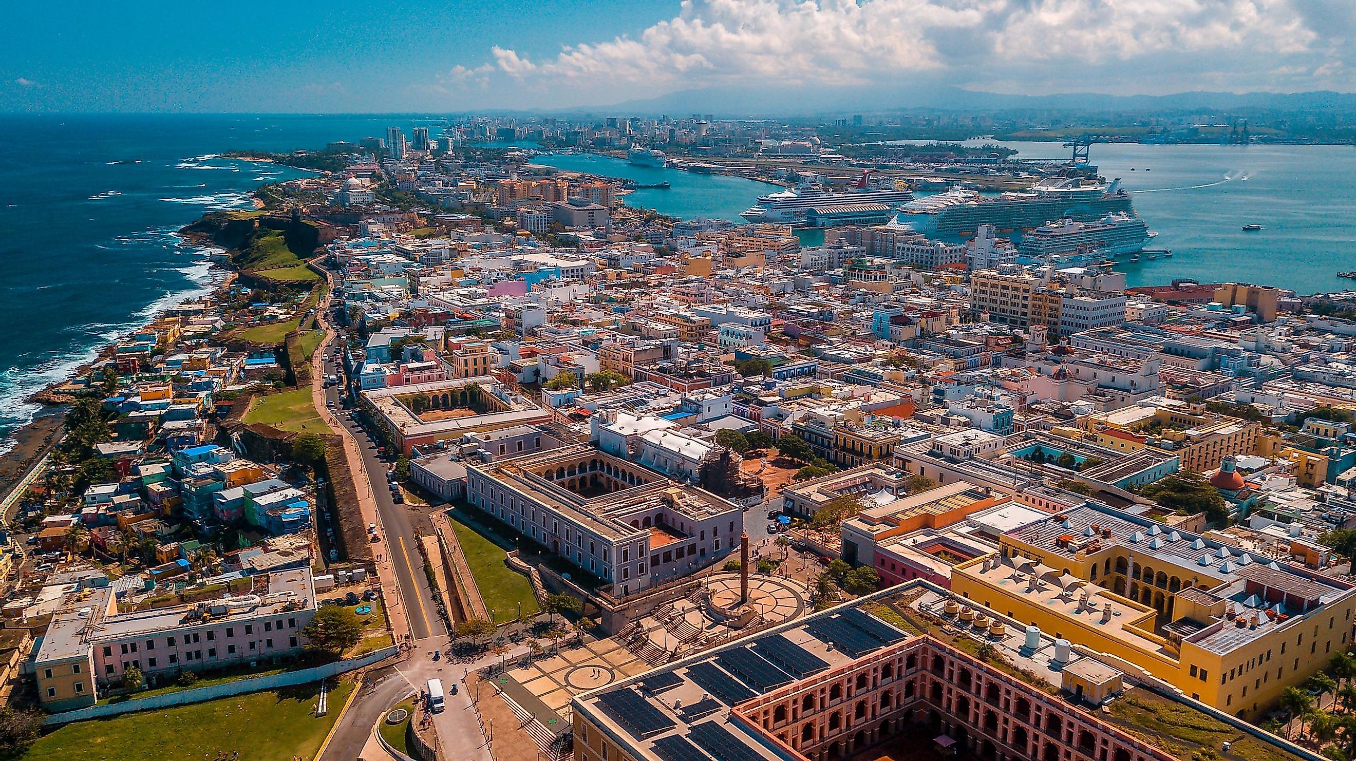
Puerto Rico

- Total area: 3,424 square miles (8,868 square km)
- Population: 2,829,148
- Capital: San Juan
- Largest city/town: San Juan
Puerto Rico stands as the most populous US territory, home to over 2.8 million individuals. Situated as an island in the Caribbean Sea, it lies just east of the Dominican Republic. Originally a Spanish colony, Puerto Rico came under US jurisdiction following the Spanish-American War of 1898 and has remained so since. Structurally, its governance mirrors that of a US state, featuring an executive governor and a bicameral legislature comprising a Senate and House of Representatives.
The population of Puerto Rico reflects a rich diversity, shaped by a history of conquest and the legacy of the slave trade. Predominantly Roman Catholic, the territory recognizes both Spanish and English as official languages. In the 2020 US elections, Puerto Rico conducted a referendum regarding its potential status as the 51st state. Although a slim majority of Puerto Ricans voted in favor of statehood, the decision ultimately rests with the US Congress to determine the territory's fate.
Guam

- Total area: 217 square miles (561 square km)
- Population: 169,387
- Capital: Hagåtña
- Largest city/town: Dededo
Guam is an island in the northern Pacific Ocean, home to more than 168,700 people. The largest ethnic group on the island is its native inhabitants, the Chamorro. There is also a large population of Filipino descent. Most of the island’s other residents are of mixed ethnic ancestry. Like Puerto Rico, Guam was also a Spanish possession until it was ceded to the US after the 1898 Spanish-American war. After World War II, Guam became an important military installation. Aside from military activity, tourism is the territory’s main industry. Guam also has the distinction of being the very first US territory to legalize same-sex marriage, following a court ruling in 2015.
US Virgin Islands

- Total area: 135 square miles (350 square km)
- Population: 104,361
- Capital: Charlotte Amalie
- Largest city/town: St Croix
The US Virgin Islands is another of America’s territories in the Caribbean, which they purchased the islands from Denmark in 1917. To the east of the US Virgin Islands are the British Virgin Islands and Puerto Rico lies about 40 miles (64 km) to the west. The main islands of this US territory are St. Croix, St. John, and St. Thomas. There are also about 50 islets and cays that are considered to be part of the US Virgin Islands. Three-quarters of the islands’ inhabitants are Black, and about a tenth are white. English is the territory’s official language, though there are some residents who speak French or Spanish. Tourism and other services are the mainstays of the economy in the US Virgin Islands.
Northern Mariana Islands

- Total area: 176.5 square miles (457.1 square km)
- Population: 57,701
- Capital: Saipan
- Largest city/town: Saipan
Just north of Guam lies another US territory in the Pacific Ocean, the Northern Mariana Islands. The territory consists of 22 islands and islets, and is a self-governing commonwealth. The only other such territory in association with the US is Puerto Rico. These islands are home to more than 57,500 people, many of them Indigenous inhabitants of Micronesian heritage. Like other US island territories, tourism is the principal driver of the economy in the Northern Mariana Islands.
American Samoa

- Total area: 77 square miles (200 square km)
- Population: 55,140
- Capital: Pago Pago
- Largest city/town: Pago Pago
American Samoa is a US territory in a remote part of the South Pacific known as Polynesia. The territory consists of six islands and is bordered immediately to the west by the independent country of Samoa. Unlike other US territories with permanent populations, American Samoa is an unorganized territory, meaning that the US Congress has never passed an organic act formally establishing an autonomous government therein. In 1951, the US Department of the Interior was given authority to administer American Samoa, and in 1967 the territory was allowed to write its own constitution. Therefore, in practice, the territory does have some degree of self-governance. The vast majority of the population in American Samoa, numbering just over 55,000, is of native Samoan ancestry. They are US nationals so they may enter and reside in the country, but they do not have citizenship.
Midway Atoll

- Total area: 2.4 square miles (6.2 square km)
- Population: 40
Midway Atoll lies in the central Pacific Ocean, 1,300 miles (2,100 km) northwest of the Hawaiian state capital, Honolulu. If the name Midway sounds familiar to you, it may be because it is also the name of an important battle in World War II, the Battle of Midway, which took place from June 3rd to 6th, northwest of the territory. Historians credit the American victory over Japanese forces in this battle as the turning point for the war in the Pacific. Today, Midway Atoll is a protected wildlife refuge. There is a very small population on the atoll, but no Indigenous inhabitants.
Palmyra Atoll

- Total area: 4.6 square miles (11.9 square km)
- Population: 20 (no permanent inhabitants)
The Palmyra Atoll is part of the volcanic island chain known as the Northern Line Islands and is located about 1,000 miles southwest of Honolulu. The atoll is named after the first American ship to make landfall there in 1802. Once a producer of copra and home to US airstrips during WWII, Palmyra Atoll is now a US National Wildlife Refuge and is also part of the Pacific Remote Islands Marine National Monument.
Baker Island

- Total area: 0.6 square miles (1.5 square km)
Baker Island is an atoll located in the South Pacific. It was claimed by the US in 1857 and has been under US sovereignty ever since. During WWII, an airbase was built on the atoll. Today, Baker Island is a US National Wildlife Refuge, and is home to endangered sea turtles. Scientists will sometimes stay on the atoll temporarily, but otherwise there are no permanent inhabitants.
Howland Island

- Total area: 0.6 square miles (1.6 square km)
Howland Island, like Baker Island, was claimed by the US in 1857. The two islands are actually in relatively close proximity to each other, and both were once the home of guano deposits, but these were exhausted in the 19th century. Howland Island once served as a stopover for planes traveling between Hawaii and Australia, and it is near here that Amelia Earheart disappeared in her attempted flight around the world. Today, just like Palmyra Atoll and Baker Island, Howland Island is a US National Wildlife Refuge and part of the Pacific Remote Islands Marine National Monument.
Jarvis Island

- Total area: 1.6 square miles (4.1 square km)
Jarvis Island is located in the South Pacific, just southwest of the small country known as Kiribati. Like Palmyra Atoll, Baker Island, and Howland Island, Jarvis Island was formerly exploited for its guano deposits. The island is home to a submarine terrace, which extends to 1 km (0.62 miles) offshore. It is also a US National Wildlife Refuge and part of the Pacific Remote Islands Marine National Monument.
Johnston Atoll

The Johnston Atoll is the closest of the US-controlled atolls in the Pacific to the main Hawaiian Islands, about 825 miles (1,330 km) southwest of Honolulu. Some of Johnston Atoll is actually man-made. In fact, two out of four of the island's reefs were artificially created by dredging.
Kingman Reef

- Total area: 0.01 square miles (0.03 square km)
Kingman Reef is located to the northwest of the aforementioned nation of Kiribati, relatively close to Jarvis Island. The island was formally annexed by the U.S. in 1922, and made into a naval reservation 12 years later. It remained a naval reserve until the year 2000, when it was transferred to the US Fish and Wildlife Service. One year later, the island was made a U.S. National Wildlife Refuge.
Wake Island

- Total area: 2.5 square miles (6.5 square km)
Wake Island is located in the central Pacific Ocean, about 2,300 miles west of Honolulu. The territory is made up of three coral islets that surround a lagoon, which is also the crater of a volcano. The US claimed the territory in 1899 and in 1934, Wake Island was put under the jurisdiction of the US Navy. In 1941, Japanese Imperial forces attacked and occupied Wake Island, but it was returned to U.S. control after Japan surrendered at the end of WWII.
Navassa Island

- Total area: 2.1 square miles (5.4 square km)
Navassa Island is a Caribbean island located close to the west coast of Haiti. The US took control of the island in 1857 and exploited phosphate there until the end of the century. In 1999, Navassa Island was made into a wildlife refuge.
Legal Status Of US Territory Residents
Residents of all but one of the permanently-inhabited US territories are American citizens. People in American Samoa are just considered American nationals, not citizens, meaning that they are free to travel within all of US territory, but do not have the rights and privileges that the US Constitution bestows on American citizens. In addition, US citizens in the territories do not vote in Presidential Elections. Their representation in the US Congress is also extremely limited. Residents of Puerto Rico, Guam, and the US Virgin Islands elect representatives that sit in the US House of Representatives, but they have few to no voting rights in the chamber. Residents of the territories who move to one of the 50 states, however, can fully participate in US elections. For example, there is a sizeable Puerto Rican community in certain parts of the US mainland.
| Rank | Territory | Location | Population | Status |
|---|---|---|---|---|
| 1 | Puerto Rico | Caribbean Sea | 2,860,853 | unincorporated, organized |
| 2 | Guam | Pacific Ocean | 168,775 | unincorporated, organized |
| 3 | US Virgin Islands | Caribbean Sea | 104,425 | unincorporated, organized |
| 4 | Northern Mariana Islands | Pacific Ocean | 57,559 | unincorporated, organized |
| 5 | American Samoa | Pacific Ocean | 55,191 | unincorporated, unorganized |
| 6 | Midway Atoll | Pacific Ocean | 40 | unincorporated, unorganized |
| 7 | Palmyra Atoll | Pacific Ocean | 20 | incorporated, unorganized |
| 8 | Baker Island | Pacific Ocean | 0 | unincorporated, unorganized |
| 9 | Howland Island | Pacific Ocean | 0 | unincorporated, unorganized |
| 10 | Jarvis Island | Pacific Ocean | 0 | unincorporated, unorganized |
| 11 | Johnston Atoll | Pacific Ocean | 0 | unincorporated, unorganized |
| 12 | Kingman Reef | Pacific Ocean | 0 | unincorporated, unorganized |
| 13 | Wake Island | Pacific Ocean | 0 | unincorporated, unorganized |
| 14 | Navassa Island | Caribbean Sea | 0 | unincorporated, unorganized |