Time Zones Of The US
Time defines how we structure our days, schedule our lives, and connect across distances. In the United States—a country that stretches over 3,000 miles from the Atlantic to the Pacific—the concept of time becomes more than just a ticking clock. It becomes geography. America’s time zones are a testament to its vastness, its history, and its need for temporal order in an age of railroads, aviation, and instant communication.
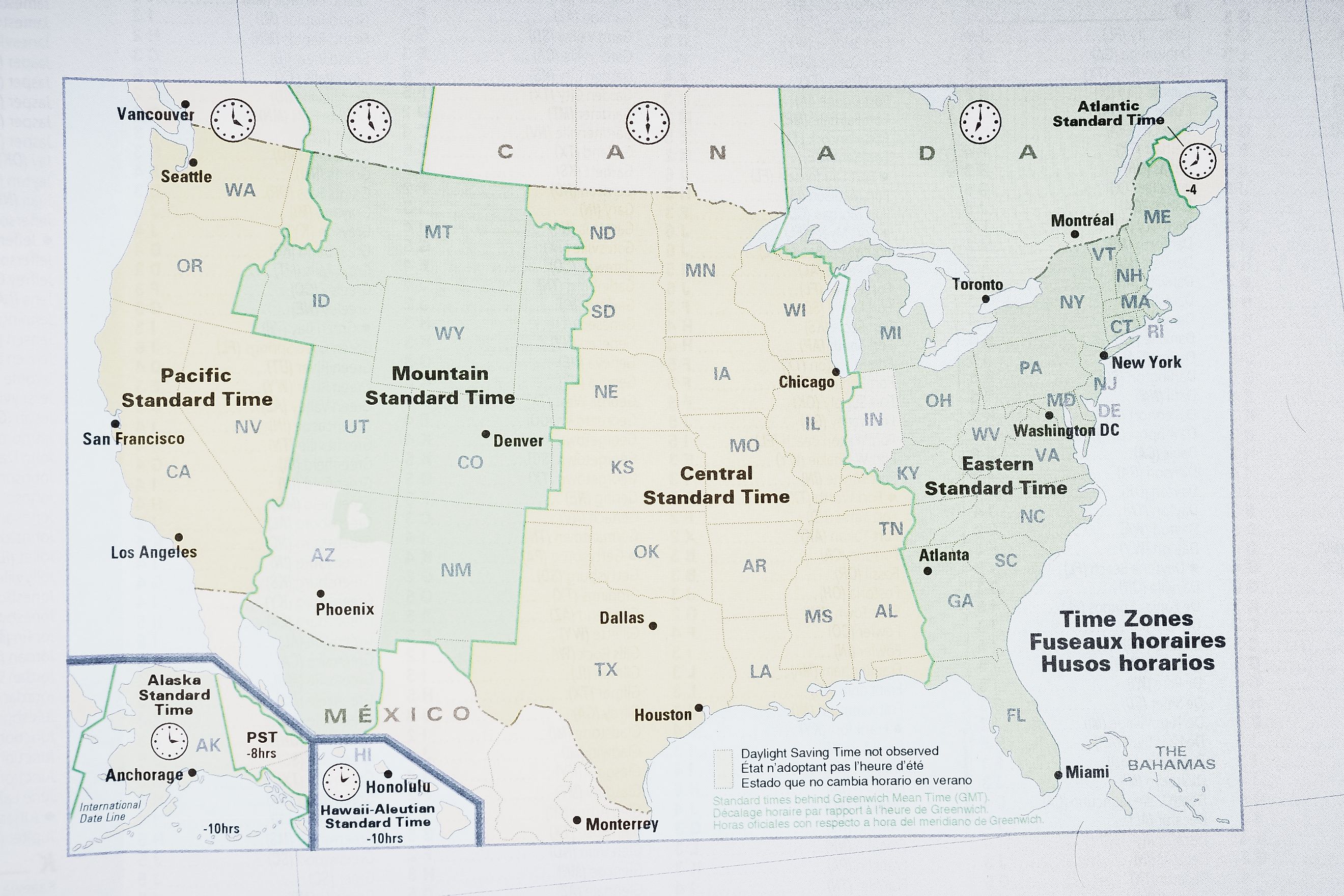
There are six primary time zones in the United States, each serving as a temporal reference for a different part of the country. They are: Eastern, Central, Mountain, Pacific, Alaska, and Hawaii-Aleutian. In addition to these, US territories like Puerto Rico, Guam, and American Samoa operate in their own respective time zones, adding further complexity to the nation's timekeeping framework.
A Brief History of US Time Zones

Before the late 19th century, time was a local affair. Each city or town set its clocks based on the position of the sun, meaning noon in New York could differ by minutes—or even hours—from noon in Chicago. This worked fine until the rise of the railroads, which required a standardized way to coordinate schedules across long distances.
The solution came on November 18, 1883, when American and Canadian railroads instituted the Standard Time System, dividing the continent into four zones: Eastern, Central, Mountain, and Pacific. This shift wasn't federally mandated—it was a matter of industry coordination—but it was quickly adopted by much of the public. It wasn’t until 1918, with the passage of the Standard Time Act, that the US government officially recognized these zones and authorized the Interstate Commerce Commission (ICC) to oversee time zone boundaries.
Today, the US Department of Transportation manages time zones, determining when and where changes can be made.
The Six Primary US Time Zones

Eastern Time (ET) – UTC−5 (Standard), UTC−4 (Daylight Saving)
The Eastern Time Zone is the most populous in the United States, encompassing roughly half the country’s population. It includes major metropolitan hubs like New York City, Washington D.C., Atlanta, Miami, and Boston.
States fully in ET:
-
New York
-
New Jersey
-
Massachusetts
-
Florida (except the western Panhandle)
-
Georgia
-
Ohio
-
Pennsylvania
-
South Carolina
Partially in ET:
-
Michigan
-
Indiana
-
Tennessee
-
Kentucky
-
Florida Panhandle
Eastern Time is considered the “default” US time zone in media and broadcasting—most national schedules are announced in ET first.
Central Time (CT) – UTC−6 (Standard), UTC−5 (Daylight Saving)
One hour behind the East Coast, Central Time covers the heartland of the US, both culturally and geographically. Cities such as Chicago, Dallas, Houston, and Minneapolis operate on CT.
States fully in CT:
-
Alabama
-
Arkansas
-
Illinois
-
Iowa
-
Louisiana
-
Minnesota
-
Mississippi
-
Missouri
-
Wisconsin
Partially in CT:
-
Kansas
-
Nebraska
-
North Dakota
-
South Dakota
-
Texas
-
Florida Panhandle
-
Indiana
-
Kentucky
-
Tennessee
This zone is essential for coordinating transportation, media, and business across the Midwest and Southern US.
Mountain Time (MT) – UTC−7 (Standard), UTC−6 (Daylight Saving)
Spanning the Rocky Mountains and parts of the Southwest, Mountain Time covers some of the most scenic—and least populated—regions of the continental US Cities like Denver, Salt Lake City, Phoenix, and Albuquerque fall into this zone.
States fully in MT:
-
New Mexico
-
Arizona (does not observe Daylight Saving Time)
Partially in MT:
-
Colorado
-
Utah
-
Wyoming
-
Montana
-
Idaho
-
North Dakota
-
South Dakota
-
Oregon
-
Nebraska
-
Texas
A quirk of Mountain Time is Arizona, which stays on Standard Time year-round, effectively syncing with Pacific Time for part of the year.
Pacific Time (PT) – UTC−8 (Standard), UTC−7 (Daylight Saving)
Pacific Time stretches along the West Coast, home to the tech industry, entertainment hubs, and vast natural beauty. Los Angeles, San Francisco, Seattle, and Las Vegas are among the prominent cities in this zone.
States fully in PT:
-
California
-
Washington
-
Nevada
Partially in PT:
-
Oregon
-
Idaho
As one of the final time zones in the contiguous US, Pacific Time often serves as the "end of the line" for national broadcasts and elections.
Alaska Time (AKT) – UTC−9 (Standard), UTC−8 (Daylight Saving)
Covering a massive expanse of territory but a relatively small population, Alaska Time keeps the state's far-flung communities coordinated. The zone spans across a landscape where daylight hours vary dramatically between seasons.
Entirely in AKT:
-
Most of Alaska, excluding the Aleutian Islands
Alaska Time is two hours behind Pacific and four behind Eastern Time, creating a unique rhythm for business and media.
Hawaii–Aleutian Time (HAT) – UTC−10 (Standard), no Daylight Saving in Hawaii
Hawaii, 2,400 miles from the US mainland, operates on its own time—and does not observe Daylight Saving Time. The Aleutian Islands, part of Alaska, also follow this time zone but do observe DST, making the zone’s behavior vary within itself.
Entirely in HAT:
-
Hawaii
-
Western Aleutian Islands (Alaska)
This zone is five hours behind Eastern Time in winter, and six hours behind during daylight saving months.
US Territories and Their Time Zones

The United States has several overseas territories, each operating in its own time zone:
-
Puerto Rico and the US Virgin Islands: Atlantic Standard Time (UTC−4), no Daylight Saving
-
Guam and the Northern Mariana Islands: Chamorro Standard Time (UTC+10)
-
American Samoa: Samoa Standard Time (UTC−11)
These time zones often place US territories a full day ahead or behind parts of the mainland. For example, Guam is 14–15 hours ahead of Eastern Time, depending on the time of year.
Daylight Saving Time: A Layer of Complexity

Most of the US observes Daylight Saving Time (DST), moving clocks forward one hour in the spring and back in the fall. However, there are important exceptions:
-
Arizona does not observe DST (except for the Navajo Nation, which does).
-
Hawaii does not observe DST at all.
-
US territories like Puerto Rico, Guam, and American Samoa also opt out of DST.
Daylight Saving begins on the second Sunday in March and ends on the first Sunday in November. This temporal shift affects everything from flight schedules to international conference calls and TV broadcasts.
Time Zone Oddities and Local Variations

While time zones may appear to follow neat vertical lines, reality is messier. Time zone boundaries bend and zigzag based on population centers, political decisions, and economic ties.
Examples include:
-
Indiana, which historically straddled multiple time zones and only standardized DST rules in 2006.
-
Kentucky and Tennessee, which are split between Eastern and Central Time.
-
Idaho, where the northern panhandle aligns with Pacific Time due to its closer ties to Washington state.
These irregularities stem from practical considerations—commerce, commuting patterns, and media markets all influence where a time zone line is drawn.
Why Time Zones Matter

Time zones affect every corner of American life. They determine when schools open, when Wall Street opens, when sports games are broadcast, and when ballots are counted. They influence energy consumption, television ratings, and business meetings across coasts.
In the age of remote work and digital connectivity, knowing the US time zones—and how they function—is more relevant than ever. Whether you're scheduling a call with a colleague in Denver, tuning in to a prime-time show in Los Angeles, or flying from Boston to Honolulu, you're navigating a complex but essential layer of American infrastructure: time itself.