Mount Whitney
Towering above the eastern horizon of California, Mount Whitney stands as the highest summit in the contiguous United States. Rising to an officially recognized elevation of 14,505 feet, this mighty peak draws hikers, climbers, geologists, and adventurers from around the world.
With its dramatic alpine setting, storied past, and challenging trails, Mount Whitney is more than just a high point on a map—it’s a symbol of the American wilderness and a bucket-list destination for anyone seeking the top of the lower 48.
Where Is Mount Whitney?

Mount Whitney anchors the Sierra Nevada mountain range in eastern California, straddling the boundary between Inyo and Tulare counties. Its west side lies within the boundaries of Sequoia National Park, while its eastern slopes descend sharply into the Inyo National Forest above the town of Lone Pine. At just over 84 miles northwest of Death Valley’s Badwater Basin—the lowest point in North America—Whitney marks the upper end of one of the most dramatic elevation changes on Earth.
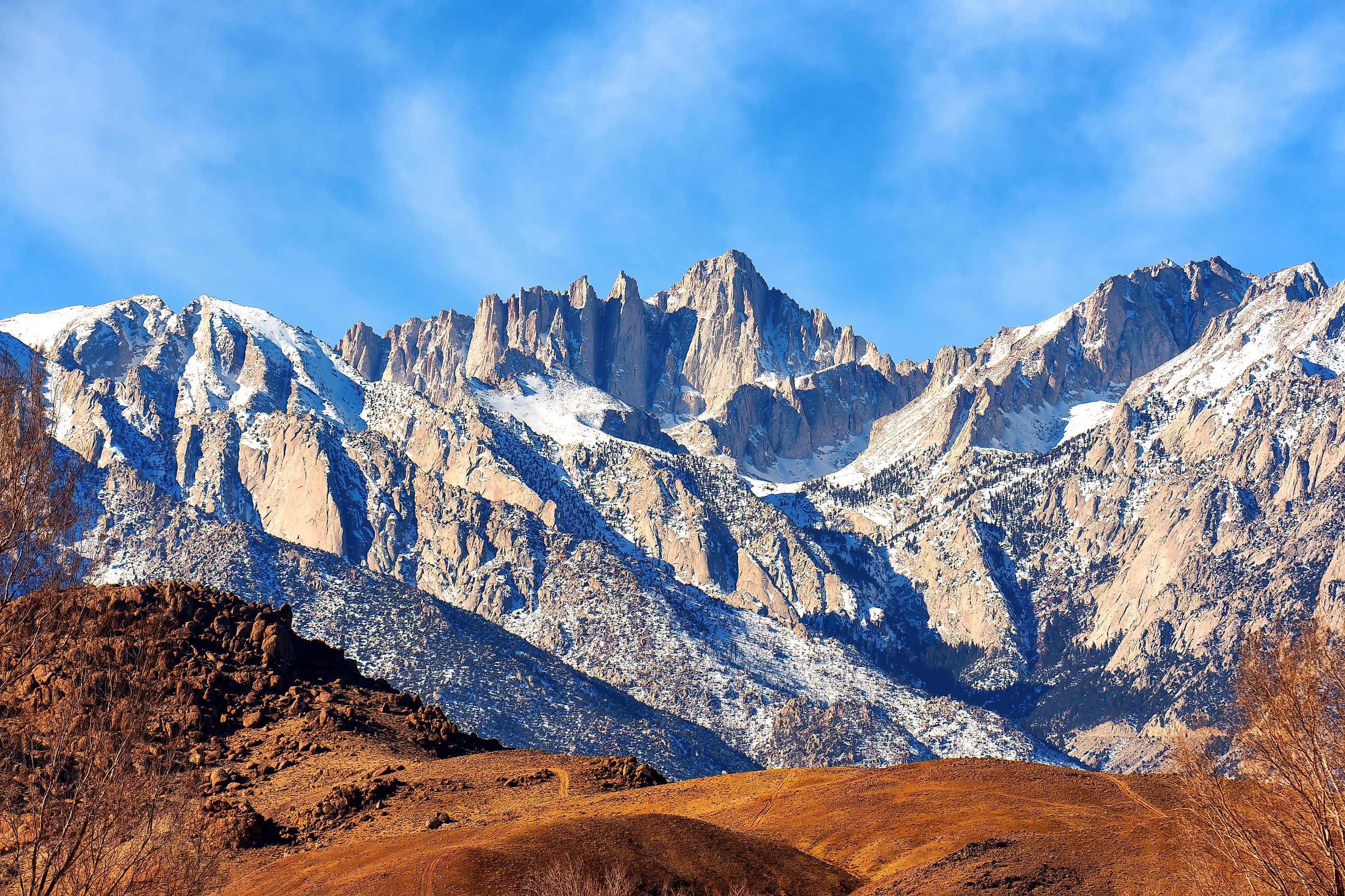
Geological Formation and Physical Features

Mount Whitney is part of the Sierra Nevada Batholith, a massive body of granite formed deep beneath the Earth's surface during the Cretaceous period. This granite was uplifted millions of years ago through tectonic activity, gradually exposed as softer surrounding rock eroded away.
Unlike many peaks shaped by glaciers, Whitney’s summit remains relatively unscathed by glaciation. Instead, it presents a broad, flat table-like summit with sheer cliffs, jagged ridges, and steep avalanche chutes on its flanks. On the eastern side, the mountain rises more than 10,000 feet above the Owens Valley floor in a mere 15 miles—one of the sharpest elevation gains in the continental US.
Its location atop the Great Basin Divide means Whitney plays a crucial role in regional hydrology. Snowmelt on the western slopes feeds the Kern River, while the eastern slopes drain into Lone Pine Creek, ultimately diverted to the Los Angeles Aqueduct.
Elevation: Why the Numbers Vary

While the elevation stamped on the U.S. Geological Survey benchmark at the summit reads 14,494 feet, modern GPS-based measurements using updated vertical datums have pushed the official elevation to 14,505 feet. This makes Whitney the undisputed tallest peak in the lower 48 states. The variance in numbers stems from changes in how we measure elevation and improvements in geoid modeling over time.
Climate and Ecology at the Top of California

Mount Whitney exists in an alpine tundra climate zone, where conditions are harsh year-round. Winter temperatures can drop below zero, while even in summer, freezing nights are common at higher elevations. Snowfall is significant and persistent, and sudden storms—including those producing dangerous lightning—can strike any time of year.
Above the tree line, vegetation is sparse. Hardy alpine flora such as sky pilot (Polemonium eximium), a low-growing cushion plant, are among the few species to survive near the summit. Wildlife is equally limited—occasional birds like the gray-crowned rosy finch and insects like butterflies may appear, but permanent animal residents are virtually nonexistent.
A Peak with Deep Historical Roots

Long before Westerners arrived, Native American groups in the region, including the Paiute people, revered the mountain. The Paiute name for Mount Whitney, Too-man-i-goo-yah, translates to “the very old man,” a nod to the mountain’s spiritual significance.
The modern name “Mount Whitney” dates back to 1864, when the California Geological Survey named it after Josiah Dwight Whitney, a prominent geologist and survey sponsor. The first recorded ascent came nearly a decade later, on August 18, 1873, when three fishermen from Lone Pine—Charles Begole, A.H. Johnson, and John Lucas—reached the summit during a Kern Canyon expedition. They originally called it "Fisherman’s Peak."
Famed geologist Clarence King mistakenly summited nearby Mount Langley in 1871, believing it to be Whitney. After learning of the error, he climbed the actual summit in 1873—only to find that locals had beaten him to the top by a month.
The Trail to the Top

The most popular route to the summit is the Mount Whitney Trail, which begins at Whitney Portal, located 13 miles west of Lone Pine at 8,360 feet in elevation. From there, hikers face a grueling 22-mile round trip with a 6,100-foot vertical gain. Most make the trek over two or three days, setting up camp at sites like Outpost Camp or Trail Camp.
Permits are required to hike or climb Mount Whitney, and due to the high volume of interest, the Inyo National Forest holds an annual permit lottery. Applications open from February 1 through March 15 each year, with winners typically announced in early April. The strict permit system helps preserve the fragile alpine environment and reduce overcrowding on the trail.
The Mountaineer’s Route and Other Paths

While the Whitney Trail is the most accessible path, more seasoned climbers often opt for the Mountaineer’s Route—a steeper, less-developed trail first ascended by legendary naturalist John Muir. This class 3 route (meaning it requires hand-and-foot climbing but is not considered technical) offers a more direct ascent from the east and is especially popular in spring and early summer when snow still covers the gully.
Other approaches to Whitney’s summit include connecting via the John Muir Trail, which traverses 211 miles from Yosemite Valley to Whitney’s peak. For many thru-hikers, summiting Whitney is a climactic end to a journey through the heart of the Sierra Nevada.
Tragedy and Shelter on the Summit

Though beautiful, Whitney can be deadly. In 1904, just days after the trail’s completion, government worker Byrd Surby became the first recorded fatality on the mountain after a lightning strike. In response, trail engineer Gustave Marsh built a stone hut at the summit in 1909—the Smithsonian Institution Shelter—which still stands today. Designed to protect against lightning and sudden storms, it remains a key landmark for summit hikers.
Cultural Legacy and Modern Significance

Mount Whitney has inspired scientists, conservationists, and adventurers for generations. In 1881, the founder of the Smithsonian Astrophysical Observatory, Samuel Pierpont Langley, set up equipment at the summit to study solar heat. Over the years, the mountain has been the backdrop for countless scientific endeavors, photography expeditions, and even proposals to rename it in honor of Winston Churchill—an idea that never took root.
Today, Whitney continues to represent the spirit of American exploration. It challenges the body, rewards the soul, and offers panoramic views of the Sierra’s granite cathedrals and the stark desert below.
Tips for Hiking Mount Whitney

If you're planning to take on Mount Whitney, keep these tips in mind:
-
Get your permit early: Apply for the lottery in February or check for cancellations closer to your desired date.
-
Train beforehand: At over 14,000 feet, the altitude can be punishing. Acclimatize if you can and come prepared for a strenuous effort.
-
Watch the weather: Afternoon thunderstorms are common in summer, especially above the tree line. Start early and aim to summit by noon.
-
Pack smart: Whether you’re day hiking or backpacking, bring warm clothing, sun protection, ample food, and plenty of water or a filtration method.
-
Respect the mountain: Stay on designated trails, pack out your trash, and follow Leave No Trace principles to help protect this fragile environment.
Frequently Asked Questions
How hard is it to climb Mount Whitney?
While non-technical via the main trail, the elevation and distance make it a challenging hike, especially for those not acclimated to high altitudes.
Can you summit in one day?
Yes, many fit hikers attempt a one-day round trip. However, it requires an early start (often before 4 a.m.) and a strong fitness level.
When is the best time to climb?
The best window is typically late June through September, when the trail is mostly free of snow and the weather is relatively stable.
Are there age restrictions?
No, but the strenuous nature of the hike means participants should be in good health and prepared for alpine conditions.