Mount St. Helens
Towering over southwestern Washington, Mount Saint Helens is more than just a peak in the Cascade Range—it’s a symbol of nature’s raw, unpredictable power. Best known for its cataclysmic eruption on May 18, 1980, this stratovolcano has shaped both the physical landscape and the scientific understanding of volcanic activity in the United States.
But its story extends far beyond that single, infamous day. From a complex eruptive history to a rebirth as a living laboratory and monument, Mount Saint Helens continues to captivate scientists, adventurers, and travelers.
A Volcano with Ancient Origins

Though it gained global notoriety in 1980, Mount Saint Helens has been active for more than 300,000 years. Geologists have traced its eruptive history through alternating periods of lava-dome building and explosive events, followed by long phases of dormancy. Since the end of the last Ice Age, the volcano has erupted more than 40 times, with especially large eruptions occurring in 2340 BCE, 1480, 1482, and 1800.
After a minor eruption in 1857, the mountain entered over a century of relative calm. This quietude led many to underestimate the potential danger simmering beneath its surface—a mistake that would prove deadly.
The 1980 Eruption: America’s Most Destructive Volcanic Event

The events of May 18, 1980, remain etched into America’s geological and cultural memory. In the weeks prior, seismic activity and small eruptions had signaled that something was stirring beneath the mountain. On March 27, 1980, a steam explosion marked the beginning of Mount Saint Helens’ most devastating eruptive period.
Over the following weeks, magma built up pressure inside the volcano, causing visible changes. A bulge began growing on the north flank, stretching and warping the landscape like a balloon about to burst. Then, at 8:32 a.m. on May 18, a magnitude 5.1 earthquake triggered a massive landslide—the largest in recorded history.
This landslide uncorked the mountain like a shaken bottle of soda. The resulting lateral blast, a high-speed, superheated cloud of ash, rock, and gas, roared outwards at speeds of at least 300 miles per hour, with temperatures reaching 660°F. It scorched everything in its path across a 15-mile radius, flattening forests and melting glaciers.
Simultaneously, a vertical eruption sent a column of ash 16 miles into the sky, darkening the skies as far as Spokane, Washington, 250 miles away. Ash fell as far as central Montana, disrupting air travel and agriculture across the Northwest.
When the chaos subsided, the mountain’s once-symmetrical summit had been replaced by a horseshoe-shaped crater. The original 9,677-foot peak had collapsed into a rim now measuring 8,363 feet, leaving behind a vast scar that could be seen from miles away.
Human and Environmental Toll
The eruption killed 57 people and wiped out thousands of animals. Entire ecosystems were smothered. An estimated 200 square miles of forest were destroyed, and mudflows and pyroclastic flows buried rivers and valleys up to 17 miles from the summit. The Toutle River, once a tranquil stream, became a muddy torrent filled with debris.
A Landscape Reborn

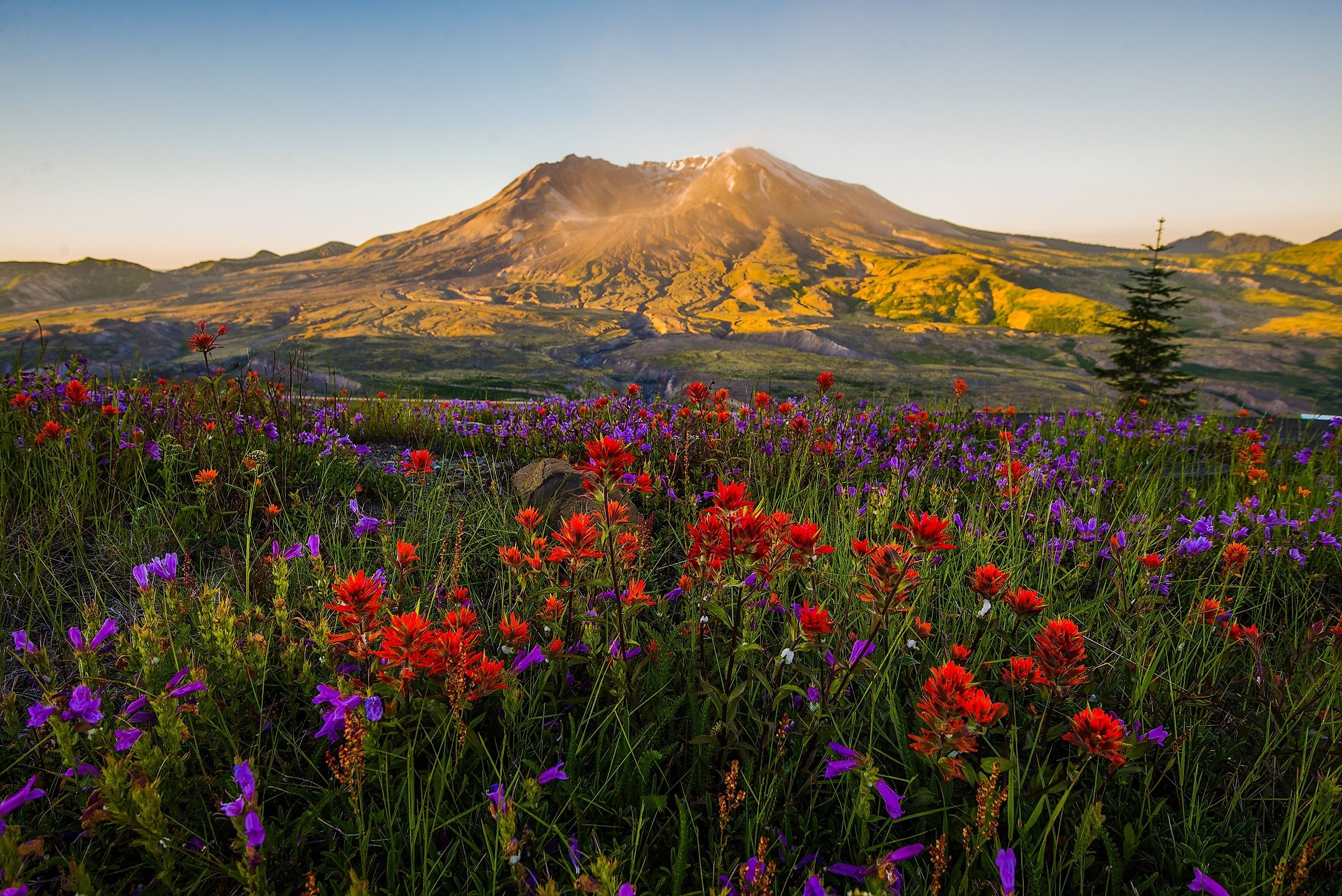
In the aftermath, the region around Mount Saint Helens looked like the surface of the moon—lifeless and grey. Yet nature is resilient. Plants and animals slowly returned, offering scientists a rare chance to study ecological recovery after a catastrophic event.
In 1982, the US government designated 172 square miles around the volcano as the Mount Saint Helens National Volcanic Monument. Administered by the U.S. Forest Service, this protected area allows natural processes to unfold with minimal human interference, making it a hotspot for both scientific research and outdoor recreation.
Exploring Mount Saint Helens Today

Visitors to Mount Saint Helens can witness both devastation and regrowth. On the west side, the Johnston Ridge Observatory, named after volcanologist David A. Johnston who perished in the 1980 eruption, provides a sweeping view of the crater and blast zone. The observatory includes exhibits, educational films, and trails that guide visitors through pumice plains and the eerie remnants of tree “ghosts” scorched by the blast.
Wildlife has also returned to the region in surprising abundance. Elk herds roam the blast zone, and newly formed lakes teem with aquatic life. On the eastern edge, old-growth forests that escaped the eruption still stand in contrast to the barren wastelands, offering a look at what once was and what may return.
On the southern side, adventurers can explore older lava formations, including Ape Cave, the longest continuous lava tube in the contiguous United States, formed during an eruption around 2,000 years ago. Hiking, spelunking, and educational ranger programs make the south side popular with families and geology enthusiasts.
Scientific Significance

Mount Saint Helens is one of the most studied volcanoes in the world, providing invaluable data for volcanologists. The 1980 eruption reshaped how scientists monitor active volcanoes, with a greater emphasis on satellite imagery, seismic activity, and ground deformation.
The volcano’s behavior continues to be closely monitored. After a period of relative calm, seismic activity resumed in the late 1980s and small eruptions occurred into the mid-1990s. Between 2004 and 2008, the mountain entered another active phase, characterized by the slow, methodical rebuilding of the lava dome within the crater.
These lava domes are key indicators of subterranean activity and pressure buildup. They also present a continual risk, as they can collapse and trigger landslides or explosive events.
How to Visit Mount Saint Helens

If you're planning a visit, here are a few key spots and tips:
Must-See Sites:
-
Johnston Ridge Observatory: Best for crater views and interpretive displays.
-
Ape Cave: A 2.5-mile-long lava tube offering an underground hike.
-
Windy Ridge Viewpoint: Eastern side access with views of Spirit Lake and the crater.
-
Lava Canyon Trail: Features waterfalls, suspension bridges, and canyon views.
-
Hummocks Trail: Hike through landslide debris and regenerating forest.
Tips:
-
Summer is best for clear views and open roads, though spring and fall offer fewer crowds.
-
Pack layers: Weather can change quickly at elevation.
-
Permits may be required for climbing or backcountry access.
-
Educational programs and ranger-led hikes are available seasonally.
Why Mount Saint Helens Still Matters

Mount Saint Helens is not just a monument to past destruction—it’s a living classroom and a dynamic symbol of regeneration. Its 1980 eruption altered US geological monitoring practices, led to the creation of a national monument, and gave scientists and the public a rare chance to witness both the fury and recovery of a volcanic landscape.
Whether you’re there to hike through a rebounding forest, gaze into the crater, or walk in the footsteps of the world’s leading volcanologists, a visit to Mount Saint Helens offers a powerful, humbling experience. It’s not just a mountain—it’s a reminder of nature’s ability to destroy, rebuild, and surprise us, time and again.
FAQs About Mount Saint Helens

Is Mount Saint Helens still active?
Yes. Although it hasn’t erupted since 2008, it remains an active volcano monitored closely by the US Geological Survey.
Can you climb Mount Saint Helens?
Yes, but a permit is required. The climb is non-technical but physically demanding, especially on the Monitor Ridge route.
What caused the 1980 eruption?
A buildup of magma caused a bulge on the mountain’s north flank. A magnitude 5.1 earthquake triggered a landslide, unleashing a massive lateral blast.
Are there other volcanoes nearby?
Yes. Mount Rainier to the northeast and Mount Adams to the east are both prominent peaks in the Cascade Range.
What wildlife can you see in the area?
Elk, black bears, mountain goats, bald eagles, and even beavers have returned to the region in large numbers.