Shasta Lake, California
Rising out of the forested canyons of Northern California, Shasta Lake is more than just a reservoir. It is a man-made marvel nestled within the steep, evergreen-lined hills of Shasta County. As the largest reservoir in California, Shasta Lake provides critical infrastructure for flood control, water supply, and hydroelectric power, while also serving as one of the state’s most beloved outdoor playgrounds.
Fed by four rivers and flanked by the towering Shasta Dam, this 30,000-acre lake is known for its houseboats, hidden coves, and miles of shoreline that rival any in the West. But beneath its sparkling surface lies a layered history, marked by displaced communities, ecological trade-offs, and ongoing environmental challenges.
How the Lake Was Formed

Shasta Lake was created with the construction of Shasta Dam, a project that began in 1935 and completed impounding water by 1944. The dam, built across the Sacramento River, is the ninth-tallest dam in the United States, rising to a height of 602 feet. It serves as a linchpin in the Central Valley Project, one of the largest water management systems in the country.
By 1948, the reservoir had reached full capacity. With a total water storage capacity of 4,552,000 acre-feet, Shasta Lake became a vital component in California’s strategy for managing both drought and flood cycles. The Shasta Powerplant below the dam generates electricity, while the water flowing out is used for irrigation and municipal systems throughout the Central Valley.
The lake sits at an elevation of 1,067 feet and reaches a maximum depth of 517 feet, giving it the volume and stature of a small inland sea.
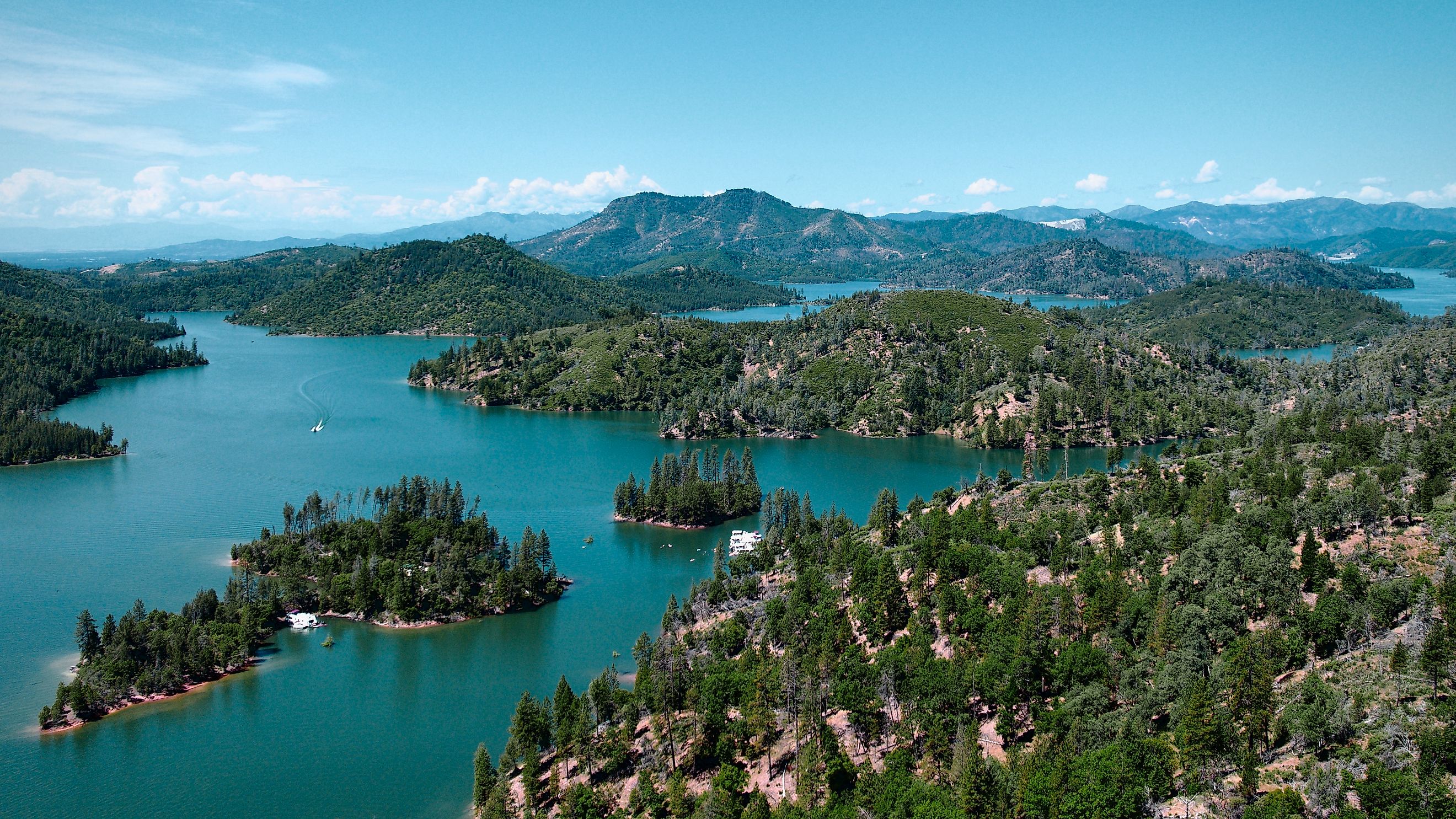
Geography and Setting: Northern California’s Water Jewel

Located just 10 miles north of Redding, Shasta Lake sprawls across the southern end of the Klamath Mountains. The terrain around the reservoir is rugged and steep, with 365 miles of shoreline that wind through canyons, cliffs, and dense forests of evergreen and manzanita.
The lake’s distinctive shape is created by four major arms, each fed by a different water source:
-
Sacramento River Arm (from the Klamath Mountains)
-
McCloud River Arm (from Mount Shasta)
-
Pit River Arm (from the Modoc Plateau near Alturas)
-
Squaw Creek Arm, sometimes referenced as Sulanharas Creek
These long, fjord-like branches stretch deep into the backcountry, providing remote inlets perfect for kayaking, fishing, and camping.
The lake’s surface area is approximately 30,000 acres, making it the third-largest body of water in California after Lake Tahoe and the Salton Sea, though it ranks first in terms of reservoir capacity.
Houseboating Capital of the West

Few places in California embody recreational freedom like Shasta Lake. Known as one of the top houseboating destinations in the United States, the lake welcomes thousands of visitors each summer to its protected coves and sun-soaked waters.
Popular activities include:
-
Boating and jet skiing across open water
-
Wakeboarding and water skiing along the arms
-
Fishing for bass, catfish, and trout
-
Camping in lakeside spots within the surrounding national forest
-
Hiking and off-road trails with panoramic lake views
Shasta Lake was also the original home of Boardstock, a wakeboarding festival that ran from 1996 to 1999. It drew international talent and tens of thousands of spectators before relocating to Clear Lake.
The lake is part of the Whiskeytown–Shasta–Trinity National Recreation Area, managed by the Shasta-Trinity National Forest. This status protects much of the surrounding landscape and provides additional campgrounds, boat ramps, and interpretive sites.
Marinas and Rentals: Gateway to the Water

A series of full-service marinas ring the lake, each offering a different experience for boaters and vacationers. Many visitors choose to rent houseboats, some large enough to accommodate full families with luxury-style amenities.
Here are some of the most prominent marinas around Shasta Lake:
-
Bridge Bay Marina: The largest marina on the lake with over 700 slips, plus a restaurant, bar, retail store, and more than 100 houseboats available for rent. Visitors can also rent jet skis, fishing boats, paddleboards, and Jetovators.
-
Shasta Marina Resort: Located near Packers Bay, this marina offers high-end houseboats, pontoon boats, and year-round amenities including a store, gas dock, and covered moorage.
-
Digger Bay Marina: About 10 miles off Interstate 5, this smaller marina has 150 slips, a retail store, and a variety of rental options for small craft.
-
Jones Valley Resort: The easternmost marina and home to the Titan, the largest rental houseboat on the lake. Six models of houseboats are available, along with watercraft rentals and fuel.
-
Silverthorn Marina: Known for its remote location on the lake’s eastern side, Silverthorn offers large houseboat rentals and quiet anchorage.
-
Antler’s Marina: The northernmost marina on the lake, located near the town of Lakehead. It offers houseboat rentals and easy access to the Sacramento River Arm.
-
Holiday Harbor: Found along the McCloud River Arm, this full-service marina includes houseboats, ski boats, and a convenience store.
-
Sugarloaf Marina: A smaller option on the Sacramento River Arm, it provides slips, overnight docking, and a general store with fuel.
Submerged History: What the Lake Covered

Before Shasta Lake ever existed, the area was home to the Wintun people, who fished, hunted, and lived in villages along the rivers that are now underwater. When the lake was filled, many of their traditional lands were permanently submerged.
Also lost beneath the water was the town of Kennett, a small mining community that vanished under the rising water. During drought years, remnants of Kennett’s buildings and structures sometimes reappear.
Parts of the old Southern Pacific Railroad tunnels and tracks are still visible at low water levels, offering a haunting look at what once was.
Shasta Lake Today

Shasta Lake is many things at once. It is a recreational hub, an engineering feat, a provider of essential water resources, and a site of environmental concern. It is also a living archive of the trade-offs that defined 20th-century infrastructure in the American West.
In wet years, it surges with vitality, drawing vacationers to its arms and houseboats to its shores. In dry years, water levels drop dramatically, exposing tree stumps, muddy inlets, and ghostly structures that hint at what was lost when the lake was created.
For all its contradictions, Shasta Lake remains one of California’s most important and beloved inland destinations. Whether for fishing at sunrise, lounging on a floating deck, or tracing the hidden stories buried beneath the waterline, Shasta Lake offers a rich and multifaceted experience.