The Seven Hills of San Francisco
San Francisco developed on steep terrain that left little room for uniform growth. Elevation dictated early road layouts, limited building types, and influenced where commerce, housing, and transportation took root. As the city expanded during the Gold Rush and beyond, its hills became fixed reference points that shaped planning decisions long before modern infrastructure arrived.
The Seven Hills of San Francisco emerged as an early geographic framework during the 19th century. Although later maps and local usage added many more named rises, these seven elevations stood out for their visibility, height, and influence on early settlement patterns: Nob Hill, Russian Hill, Telegraph Hill, Rincon Hill, Twin Peaks, Mount Davidson, and Mount Sutro.
Together, these hills form a physical record of how the city adapted to difficult topography. They affected where rail lines ran, how neighborhoods formed, and where development stalled or accelerated. Even now, their presence continues to affect movement, land use, and the visual character of San Francisco.
Nob Hill

Nob Hill rose quickly as a symbol of wealth during the late 19th century. Railroad tycoons and industrial leaders claimed its heights, choosing elevation as a public display of success. Leland Stanford, Mark Hopkins, Charles Crocker, and Collis P. Huntington built grand mansions along the crest, turning the hill into a statement of influence.
Cable car lines climbed the steep streets to serve these estates. Transportation shaped the hill’s identity early, connecting luxury above with commerce below. That physical climb mirrored social divides present at the time.
The 1906 earthquake and fire erased many original mansions. Rebuilding shifted the tone. Lavish private homes gave way to landmark hotels and institutions. The Fairmont Hotel and the Mark Hopkins Hotel brought hospitality to the hill. Grace Cathedral emerged as the architectural centerpiece, its Gothic design standing out against the skyline.
Today, Nob Hill apartments sit beside historic hotels. Churches share blocks with cafes and small shops. Its elevation still provides sweeping views.
Russian Hill

Russian Hill developed differently. Steep grades forced creative solutions rather than grand gestures. Streets twist sharply. Staircases replace sidewalks in some places. The most famous feature, Lombard Street, zigzags down the eastern slope in a series of tight turns designed to manage the incline.
Russian Hill never leaned into spectacle alone. Housing grew steadily during the early 20th century, driven by working professionals and families rather than industrial wealth. Buildings range from Edwardian flats to mid-century apartment blocks.
Western slopes face the bay, offering views that shift with fog and light. Eastern sides drop toward North Beach, linking the hill to Italian heritage, nightlife, and older port neighborhoods.
Despite postcard fame, Russian Hill functions as a residential core. Daily routines shape the streets more than tourism.
Telegraph Hill

Telegraph Hill stands close to the city’s eastern edge, rising above the waterfront. Its name traces back to a semaphore station used to signal incoming ships during the Gold Rush. Communication defined its early role.
The hill later became home to artists, writers, and independent thinkers. Coit Tower crowns the summit, built in the 1930s and decorated with murals reflecting working-class life and social ideals of the era. Those murals sparked controversy at the time, reinforcing the hill’s reputation for creative expression.
Steep stairways climb through gardens and cottages along the slopes. These pedestrian paths connect the hill to the Embarcadero and North Beach below. Parrots flying overhead have become an unexpected local feature, adding to the area’s distinct atmosphere.
Rincon Hill

Rincon Hill once ranked among the city’s most desirable addresses. During the Gold Rush, wealthy families built homes overlooking the bay and shipping lanes. Proximity to commerce made the hill valuable early.
The construction of the Bay Bridge changed everything. Infrastructure cut through the neighborhood, isolating sections and driving residents away. Industrial use followed. For decades, Rincon Hill faded from prominence.
Recent redevelopment brought another shift. High-rise residential towers now line parts of the hill, especially near the bridge approach. New housing transformed the skyline and reintroduced density to an area long overlooked.
Twin Peaks

Twin Peaks rise near the geographic center of San Francisco. Two rounded summits dominate the skyline and offer some of the most expansive views in the region. On clear days, landmarks stretch across the bay, ocean, and downtown core.
The peaks remained largely undeveloped for much of the city’s history. Wind and elevation discouraged large-scale building. Roads arrived later, opening access without overwhelming the landscape.
Twin Peaks function less as a neighborhood and more as a natural lookout. Trails circle the hills, providing space for walking and reflection. Native plants and wildlife persist here more visibly than in lower elevations.
Mount Davidson

Mount Davidson holds the title of highest natural point within city limits. Rising above Twin Peaks, it remains surprisingly quiet given its elevation. Dense vegetation covers much of the area. A large cross stands near the summit, installed in the 1930s. Over the years, the site has sparked legal and cultural debate, reflecting San Francisco’s complex relationship with public symbols and identity.
Trails wind through eucalyptus groves and native plants. Fog moves differently here, sometimes isolating the summit entirely. Residential streets circle the base, but the core stays green and undeveloped.
Mount Sutro

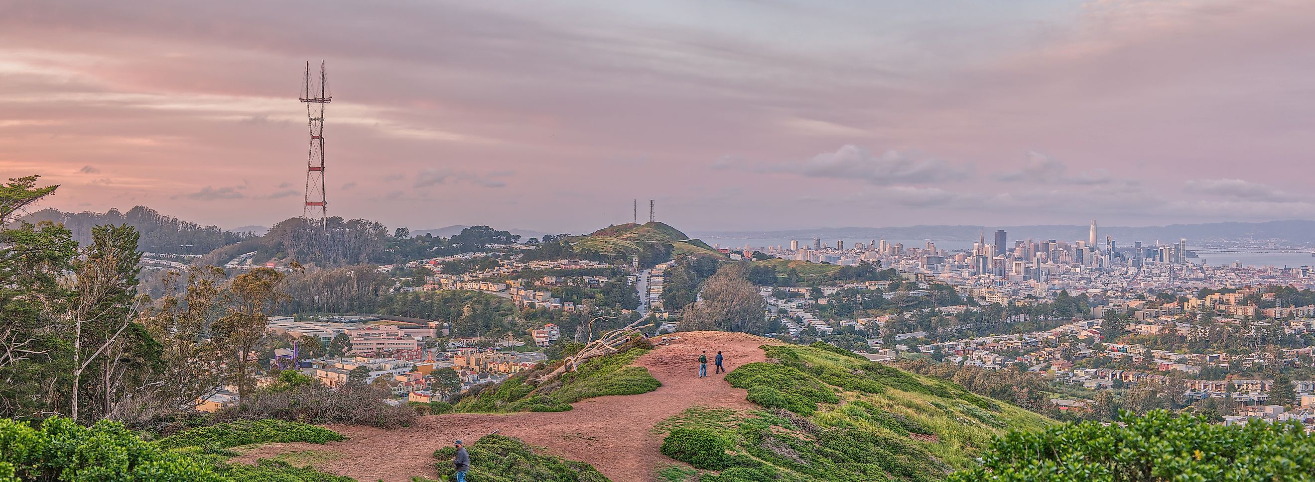
Mount Sutro sits near the western side of the city, adjacent to the University of California, San Francisco. The hill became forested after Adolph Sutro planted thousands of eucalyptus trees in the late 19th century. That decision transformed the landscape permanently.
The dense forest creates a rare environment within city limits. Trails cut through thick canopy. Light filters unevenly through tall trunks. Sound dampens under leaves and fog. Communication towers occupy the summit, blending infrastructure with nature. Access here is much more limited compared to other hills.
How the Hills Still Shape the City

The Seven Hills continue to influence San Francisco in practical ways. Street patterns, transit routes, and zoning decisions still respond to elevation changes established more than a century ago. Development varies sharply between slopes and ridgelines, creating distinct neighborhood boundaries within short distances.
These hills also shape how the city is experienced day to day. Views open suddenly, travel times shift block by block, and weather patterns change with height. Long after newer neighborhoods filled in the lowlands, the original Seven Hills remain a quiet framework beneath the city’s growth, reinforcing San Francisco’s reputation as a place where geography and urban life stay closely linked.
| Hill Name | Location in the City | Notable Features | Historical Role |
|---|---|---|---|
| Nob Hill | Northeast San Francisco | Grace Cathedral, historic hotels | Center of wealth and power during the Gold Rush era |
| Russian Hill | North-central | Lombard Street, steep stairways | Residential growth shaped by extreme elevation |
| Telegraph Hill | Eastern waterfront | Coit Tower, pedestrian staircases | Early communication point and creative enclave |
| Rincon Hill | Near Bay Bridge approach | Modern high-rises, bay views | Gold Rush elite neighborhood turned industrial, then redeveloped |
| Twin Peaks | Geographic center | Twin summits, panoramic city views | Natural lookout with minimal development |
| Mount Davidson | Southwest San Francisco | Highest natural point, wooded trails | Quiet residential hill with open green space |
| Mount Sutro | West-central | Dense eucalyptus forest, radio towers | Urban forest shaped by late 19th century planting |