America's Best Preserved Civil War Sites You Can Visit
More than 160 years after the Civil War, large pieces of the American landscape still explain the conflict better than any diagram ever could. Farm fields bend the same way they did when infantry crossed them under fire. Rivers still block movement or funnel it into narrow crossings. Town streets follow paths laid out long before traffic lights or zoning plans. In the strongest preserved places, the ground itself answers questions. Why did troops advance here. Why did fighting stall there. Why did timing matter so much.
What gives these places their power is restraint. Development sits well back from the fighting ground. Hills and ridges still connect visually. Distances still take time to cross on foot. Standing on the land makes decisions feel physical. High ground stops being an abstract idea and starts looking urgent. Narrow roads explain congestion and delay. Movement suddenly feels risky. Strategy becomes something you can sense instead of something you have to imagine.
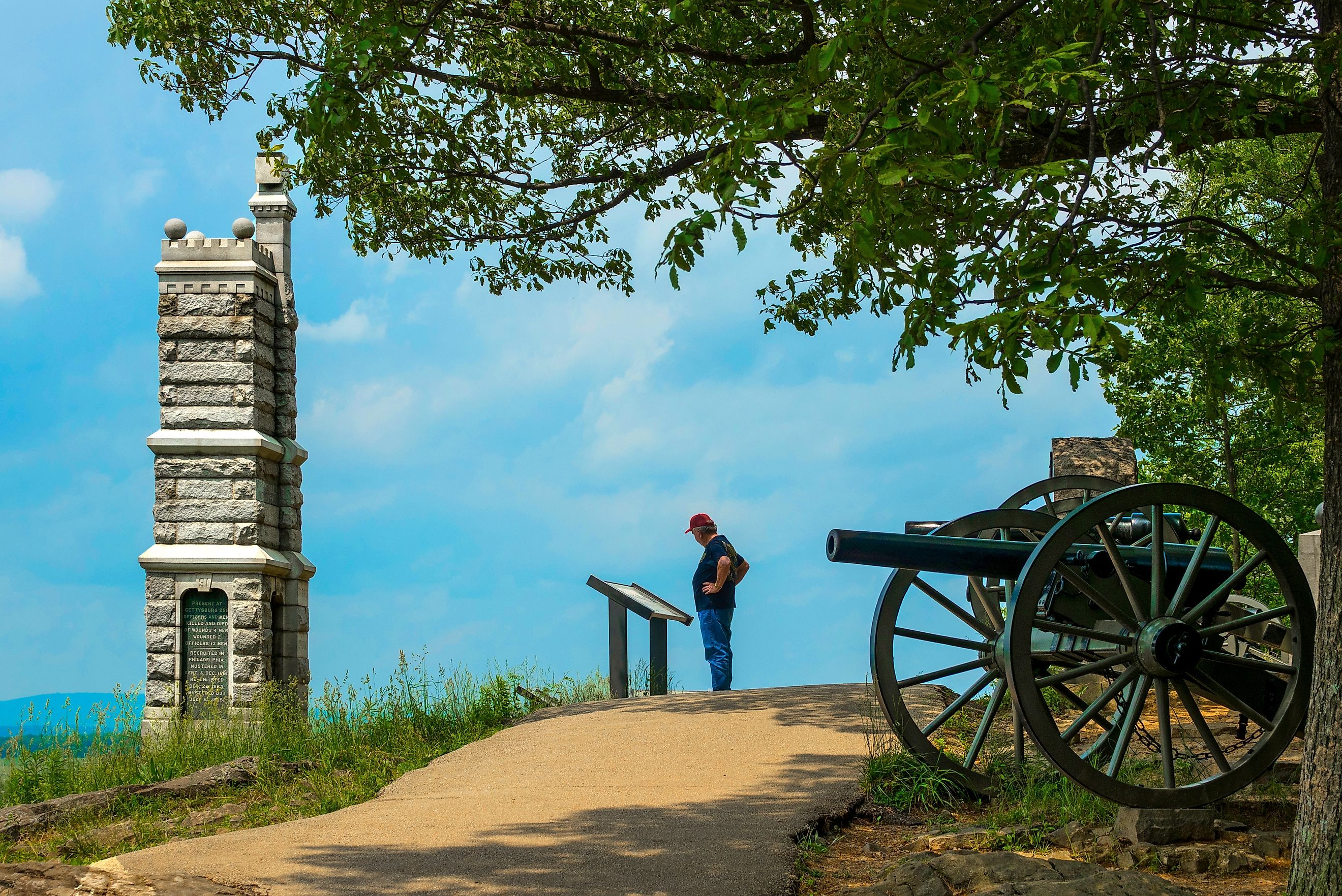
Gettysburg National Military Park, Pennsylvania

Gettysburg works because the battlefield still reads clearly at a glance. The fighting in July 1863 unfolded across ordinary farmland and a compact town. That setting has changed far less than expected for a place so well known. Seminary Ridge runs parallel to Cemetery Ridge with open ground between them. Little Round Top rises sharply at the southern end. That alignment alone explains much of the battle.
The scale matters. More than 7,000 acres remain open, which allows long views across the fields Pickett’s Charge crossed. Fences and stone walls still cut through the land, breaking lines and slowing formations. Orchard rows interrupt sightlines. Shallow dips in the ground show how limited cover really was. None of it feels theoretical once you see how exposed the terrain remains.
Gettysburg the town deepens the picture. Brick houses and public buildings served as hospitals and headquarters as fighting spilled inward. Many still stand along the same streets soldiers and civilians crowded into during those days. Preservation work focused on removing later changes rather than adding spectacle. Roads were shifted. Modern features were pulled back.
Antietam National Battlefield, Maryland

Antietam compresses the war into a single devastating day. On September 17, 1862, nearly 23,000 soldiers were killed, wounded, or missing within hours. The battlefield covers a relatively small area, making the sequence of fighting easier to trace.
The Cornfield sits at the center of that story. It looks simple on paper but became one of the most contested pieces of ground in the war. Units advanced and collapsed over the same rows again and again. Sunken Road offered protection at first, then turned deadly once attackers reached its flank. Burnside Bridge shows how a narrow crossing can dictate an entire phase of battle when alternatives do not exist.
The surrounding land continues to support that narrative. Rolling hills shape lines of fire. Stone walls divide movement. Narrow lanes explain why reinforcements struggled to arrive where they were needed. Preservation choices kept roads small and views open. Walking the field reveals how quickly plans unraveled once terrain took control.
Shiloh National Military Park, Tennessee

Shiloh forced both sides to confront the scale of the war early on. Fought near the Tennessee River in April 1862, the battle produced more than 23,000 casualties in two days. Dense woods cut visibility down to almost nothing, making it hard to see more than a short distance ahead. Ravines break up movement with little warning, and open fields appear suddenly thatleave troops exposed before there is time to adjust.
The place names still used today line up closely with the terrain. The Hornet’s Nest sits where the land naturally funneled fire into a narrow space. The Peach Orchard marks a rare clearing. Shiloh Church stands close to its wartime location and provides a clear point of reference across the battlefield.
Interpretation at Shiloh focuses on how units moved and how quickly conditions changed. Markers follow advances, retreats, and stalled attacks instead of isolating a single dramatic moment. Walking the uneven ground makes it easier to understand why coordination proved so difficult once the fighting began.
Vicksburg National Military Park, Mississippi

Vicksburg tells a slower story built around pressure and patience. For 47 days in 1863, Union forces surrounded the city and cut off supplies. The goal was control of the Mississippi River, and the land is why Vicksburg held out for so long.
High bluffs rise sharply from the river, turning the city into a natural stronghold. Trenches and artillery positions still line the hills in long curves. Walking those earthworks shows how siege warfare progressed inch by inch rather than through sweeping movement.
The city itself is part of the landscape. Hillsides show where civilians carved out caves for shelter during weeks of bombardment. Streets and elevation tie military positions directly to daily life under siege. Few places blend fighting and civilian space as completely as Vicksburg.
Manassas National Battlefield Park, Virginia

Manassas captures the moment when expectations collapsed. The first battle in July 1861 ended hopes for a short war. The second, fought a year later, confirmed that neither side was prepared for what lay ahead.
The land explains why both battles unfolded the way they did. Small streams and low ridges steer movement more than steep hills ever could. Henry Hill does not tower over the field, but its slight rise gave a clear advantage to anyone holding it. Bull Run forced troops into a handful of crossings, slowing advances and concentrating fire. When fighting reached the unfinished railroad, its deep cut in the ground turned into an instant defensive position.
Preservation work widened the battlefield and cleared later development so these features make sense again.
Appomattox Court House National Historical Park, Virginia

Appomattox tells the final chapter of the Civil War without relying on battlefield drama. In April 1865, Confederate General Robert E. Lee surrendered the Army of Northern Virginia to Union General Ulysses S. Grant at a small crossroads village. By that point, major fighting had largely stopped. What happened here mattered because it brought the war to a close.
Appomattox was a quiet rural stop, not a strategic stronghold or major town. The McLean House sits at the center of the village, where surrender terms were discussed. Surrounding buildings show how ordinary the place was, with simple roads and open fields spreading outward in every direction.
Fredericksburg and Spotsylvania National Military Park, Virginia

This park preserves four major battlefields that together trace the war’s hardest years. Fredericksburg shows how frontal assaults collapsed against prepared defenses. Stone walls and sunken roads still explain the result better than casualty figures.
Commanders struggled to see, hear, or control what was happening in Chancellorsville's thick forests. Roads disappeared into trees, units lost direction, and surprise attacks carried extra weight because visibility dropped so quickly. The Wilderness took those problems to an extreme. Dense undergrowth, smoke, and uneven ground turned large formations into scattered groups, making coordination nearly impossible and turning small mistakes into major setbacks.
Spotsylvania shows what came next. At the Mule Shoe Salient, both sides dug in and fought at close range for days, signaling a shift away from open maneuvers and toward sustained, entrenched combat. Earthworks and shallow trenches reshaped the battlefield, forcing soldiers into prolonged standoffs where movement slowed and losses mounted.
Chickamauga and Chattanooga National Military Park, Georgia and Tennessee

Chickamauga and Chattanooga preserve a turning point in the western theater. Chickamauga’s thick woods limited visibility, forcing close-range, chaotic fighting and making command extremely difficult. Troops collided unexpectedly, and confusion slowed reinforcements.
Chattanooga’s Lookout Mountain and Missionary Ridge dominated the surrounding landscape, giving Confederates control over movement and supply lines. Union forces’ capture of these heights broke Confederate positions and opened the Deep South to further campaigns. Established in 1895 as the first national military park, the site protects woods, fields, roads, and elevations that match the historical battles.
Walking Through History
Civil War battlefields do more than mark where soldiers fought. The land itself explains strategy, timing, and consequence. Open fields, wooded ridges, river crossings, and small towns shaped decisions, controlled movement, and determined outcomes.
Preservation across sites like Gettysburg, Antietam, Shiloh, Vicksburg, Manassas, Appomattox, Fredericksburg, and Chickamauga lets the terrain speak for itself. Elevation, sightlines, and natural barriers reveal why battles unfolded as they did. Standing on these grounds, it becomes clear that understanding the Civil War means paying attention to the earth beneath soldiers’ feet, not just the dates and names on a page.
| Site | Location | Acres | Notable Feature |
|---|---|---|---|
| Gettysburg National Military Park | Pennsylvania | 7,000+ | Seminary Ridge, Little Round Top, Cemetery Ridge |
| Antietam National Battlefield | Maryland | 4,000+ | Cornfield, Sunken Road (Bloody Lane), Burnside Bridge |
| Shiloh National Military Park | Tennessee | 3,500+ | Shiloh Church, Hornet’s Nest, Peach Orchard |
| Vicksburg National Military Park | Mississippi | 1,800+ | River bluffs, siege trenches, civilian caves |
| Manassas National Battlefield Park | Virginia | 5,000+ | Henry Hill, Bull Run, Unfinished Railroad Cut |
| Appomattox Court House National Historical Park | Virginia | 1,700+ | McLean House |
| Fredericksburg and Spotsylvania National Military Park | Virginia | 7,000+ | Stone walls, Sunken Road, Mule Shoe Salient |
| Chickamauga and Chattanooga National Military Park | Georgia / Tennessee | 9,500+ | Lookout Mountain, Missionary Ridge, dense woods |