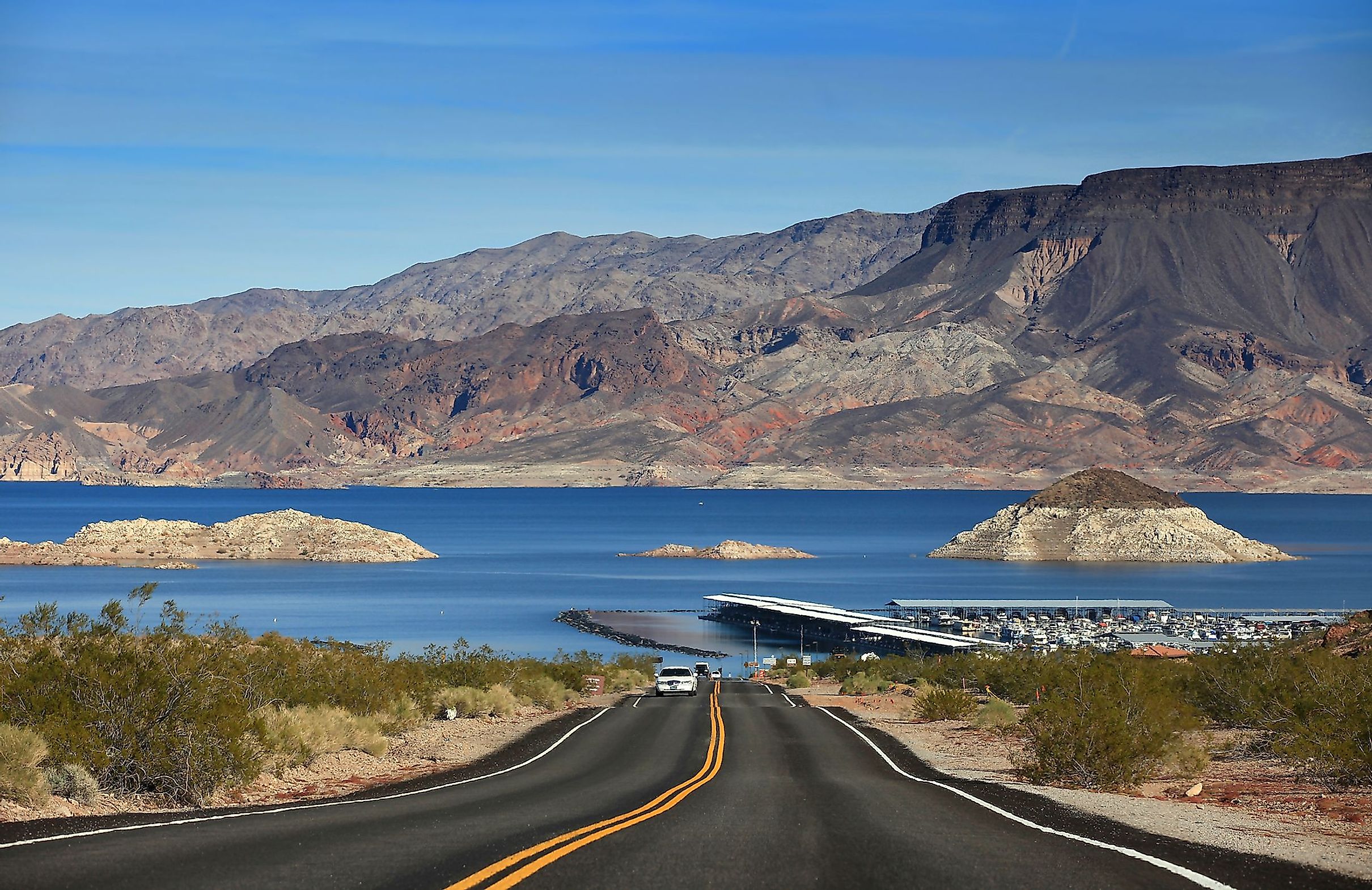
Lake Mead
Lake Mead is a large reservoir that has been created by the damming of the Colorado River by the massive Hoover Dam. In terms of water capacity, Lake Mead is considered to be the United States’ largest reservoir. The Lake Mead reservoir is situated on the boundary between the States of Arizona and Nevada, extending into Arizona’s Mohave County and Nevada’s Clark County. It is also situated about 39km to the east of the 6.8km long Las Vegas Strip. Lake Mead forms a part of a supply system that provides water for irrigation, hydroelectricity, and household uses to more than 20 million inhabitants residing in the states of Nevada, Arizona, and California as well as parts of the country of Mexico.
About Lake Mead

When filled at maximum capacity, Lake Mead has a length of 180km, a maximum width of 16km, and a maximum depth of 162m. Situated at an elevation of 372.3m, the lake covers an area of 640 sq. km and has a shore length of 1,221km. Lake Mead has a maximum capacity of 32.236 cubic kilometers of water. Lake Mead is further divided into many basins. Situated near the Hoover Dam is the Boulder Basin which is considered the largest basin of Lake Mead. On the eastern side, a narrow channel which is currently referred to as “The Narrows” links the large Boulder Basin to the Virgin Basin. The 51km long Muddy River and the 261km long Virgin River drains into the Overton Arm which is in turn linked with the northern portion of the Virgin Basin. The other basins of Lake Mead include the Temple Basin and the Gregg Basin. The Virgin Canyon connects Gregg Basin with the Temple Basin. The lake is surrounded by many serrated mountain ranges that offer spectacular scenic views during sunset. The River Mountains and the Muddy Mountains can be seen from the Boulder Basin, whereas the Bonelli Peak is situated on the eastern side of the Virgin Basin.

Lake Mead receives a major part of its water from the snowmelt in the Rocky Mountains and runoff from the states of Utah, Wyoming, and Colorado. The Glen Canyon Dam, which is situated upstream of Lake Mead, releases about 10,150,000 megalitres of water to the lake per annum. The Hoover Dam in turn releases about 11,000,000 megalitres of water to the lake annually. About 12,000,000 megalitres of water are annually lost from Lake Mead by evaporation. However, in recent years, due to increase in demand for water, high evaporation levels, reduced snowmelt runoff, changing rainfall patterns, prolonged drought, and climate change have led to a reduction in the water levels of the lake. The last approached full capacity of the lake was during the summer season of 1983 and 1999 and the capacity has been dropping ever since. Currently, the Lake Mead reservoir contains about 35.17% of its full capacity. The lower water levels mean less amount of water would be portioned out to the states in the 2022 water year.
Recreation

Lake Mead serves as a popular tourist destination and offers many recreational activities such as boating, swimming, water skiing, sunbathing, fishing, etc for its visitors. Lake Mead contains several marinas which include Lake Mead Marina, Las Vegas Boat Harbor, Callville Bay, and Temple Bar. In addition to this, there are many sand beaches, coves, small islands, the Grand Wash recreational area, and the Alan Bible Botanical Garden. However, due to decreasing water levels, the boat launch ramps and marinas of Lake Mead had to be relocated or permanently closed. In 2002, the Las Vegas Bay Marina was relocated, while the Lake Mead Marina was relocated in 2008.
Brief History

Lake Mead was created on September 30, 1935, by the massive Hoover Dam on the Black Canyon of the Colorado River. The lake has been named in the honor of the American engineer Elwood Mead, who served as the US Bureau of Reclamation’s commissioner from 1924 to 1936. During this period, Mr. Mead was involved in the planning and building of the Boulder Canyon Project that later led to the creation of the Hoover Dam and Lake Mead. Under the management of the National Park Service, the “Boulder Dam Recreation Area” was established in 1936 at Lake Mead. In 1947, the area was rechristened as the “Lake Mead National Recreation Area”. The construction of the Hoover Dam and Lake Mead had led to the forced evacuation of many communities including St. Thomas, Rioville, Callville, and Old Bonelli’s Ferry. In recent years, at lower water levels, a “bathtub ring” of minerals is visible along the lake’s steep shoreline.