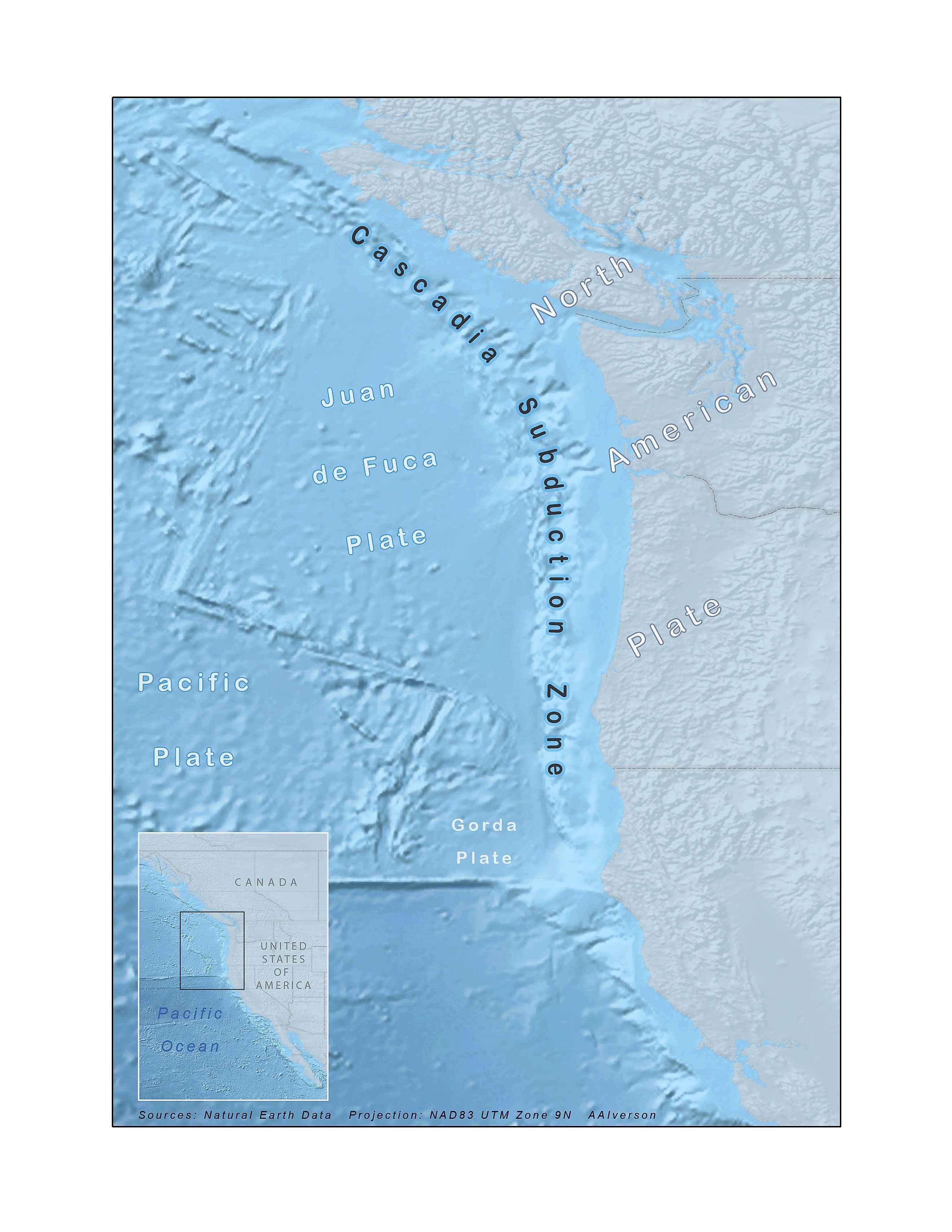
The Cascadia Subduction Zone
Beneath the calm waters of the Pacific Ocean, just 70 to 100 miles off the coast of the Pacific Northwest, lies one of the most dangerous geological features in North America: the Cascadia Subduction Zone (CSZ). This 700-mile-long fault stretches from northern California to British Columbia and is capable of producing one of the most powerful natural disasters the United States has ever seen: a magnitude 9.0 or greater earthquake followed by a towering tsunami.
Though it has been silent since January 26, 1700, scientists agree the CSZ is not dormant. It is locked, accumulating strain, and building pressure with every passing day.
What Is the Cascadia Subduction Zone?

The CSZ is a convergent plate boundary where the small but dense Juan de Fuca Plate is sliding, or subducting, beneath the massive North American Plate. This tectonic interaction is similar to other subduction zones around the Pacific Ring of Fire, such as those in Japan or Chile, that frequently produce major earthquakes.
Cascadia is different from other subduction zones in one crucial way. It produces very few small earthquakes. This quiet behavior results from intense locking between the two plates. As the plates grind against each other and refuse to slip, they store energy that can only be released during a massive seismic event.
Anatomy of a Megathrust Earthquake

In the upper portion of the fault, roughly the top 18 miles, the CSZ is tightly locked. Over time, immense pressure builds as the Juan de Fuca Plate is forced beneath the North American Plate. Eventually, the frictional resistance is overcome, and the locked plates slip violently past each other, unleashing a megathrust earthquake.
Below this locked zone is the Transition Zone, where the plates move gradually in what scientists call slow slip events. These events shift the plates just a few centimeters over the course of several months and do not produce seismic shaking. However, they contribute to stress on the locked zone above.
Deeper still, the plates slide continuously and silently. This motion does not cause earthquakes, but it adds to the complexity of how energy builds along the fault. Near the seafloor, particularly within the top three miles offshore, little is known due to limited data, leaving scientists uncertain whether this portion is also locked or slipping quietly.
The Last Time It Happened

The last known full rupture of the CSZ occurred on January 26, 1700. It was an estimated magnitude 9.0 earthquake that shook the Pacific Northwest, dropped the coastline by several feet, and unleashed a devastating tsunami.
What makes this event remarkable is that it left no written record in North America. The confirmation came from Japan, where coastal communities recorded an unexpected and powerful tsunami arriving with no accompanying local quake. Using historical records and ocean modeling, scientists linked this "orphan tsunami" to a massive earthquake originating in the Pacific Northwest.
In addition to the Japanese records, oral histories from Indigenous tribes in Oregon and Washington describe a catastrophic shaking of the earth and a massive wave that swallowed entire villages. These stories have become key pieces of evidence in understanding the timing and impact of the 1700 event.
What Scientists Know and What They Fear

Geologists have studied land-level changes and sediment deposits known as turbidites to determine that the Cascadia Subduction Zone has produced at least 43 major earthquakes over the past 10,000 years. In the last 3,500 years, there have been at least seven megathrust earthquakes. These events seem to recur every 400 to 600 years.
This means that the Pacific Northwest is now well within the expected time frame for another massive rupture. According to researchers at the M9 Project, a University of Washington-based initiative, there is a 37 percent chance of a magnitude 7.1 or greater earthquake occurring in the CSZ in the next 50 years.
A full rupture of the fault would be catastrophic, releasing seismic energy that could rival or exceed the most powerful earthquakes ever recorded.
The Human Element: How Prepared Are We?

Despite decades of warnings, many communities in Oregon, Washington, and Northern California remain vulnerable. Much of the region’s infrastructure was not built to withstand a magnitude 9.0 earthquake followed by a tsunami.
The “Be 2 Weeks Ready” initiative, led by state emergency management agencies, encourages households to stockpile food, water, medicine, and other essentials. Preparing for two weeks without outside assistance is considered the minimum goal for surviving a Cascadia event.
In 2016, the Oregon Department of Emergency Management launched the Cascadia Island Mapping Pilot Project to identify areas that would likely become isolated during an earthquake and tsunami. The project worked with local officials to determine where bridges might collapse, roads could be blocked, and how residents and visitors would be impacted. These maps help communities prioritize emergency planning and resource allocation.
Monitoring and Mitigation Efforts

To better understand the CSZ and detect early signs of rupture, scientists are using a combination of land-based GPS networks, deep-sea instruments, and satellite imaging. These tools allow researchers to monitor plate movements and identify slow slip events that may increase stress on the fault.
The US Geological Survey and other agencies are also investing in early warning systems such as ShakeAlert, which can detect seismic waves seconds before strong shaking reaches population centers. Even a short warning can allow people to drop, cover, and hold on, and give hospitals, transit systems, and utility companies a chance to take automatic safety precautions.
Meanwhile, the M9 Project continues to model potential earthquake scenarios and work with city planners, engineers, and first responders to increase resilience throughout the region.
A Race Against Time
The Cascadia Subduction Zone is one of the most dangerous geological threats in the continental United States. Although it has remained quiet for more than three centuries, geological evidence confirms that it will rupture again. Whether the next event happens in five years or 50, it will come.
Preparedness is the only defense against a disaster of this scale. The science is clear, and the warnings are in place. The challenge now is to act while there is still time.