Where Does the Mississippi River Start and End?
The Mississippi River is one of the most iconic waterways in the United States, playing a central role in the country’s geography, history, and economy. Stretching thousands of miles through the heart of America, this legendary river has served as a natural highway, a boundary marker, a cultural touchstone, and a vital source of life and commerce.
But where exactly does the Mississippi River begin, and where does it end? Trace the river from its quiet headwaters in northern Minnesota to its sprawling delta in the Gulf of America, providing insight into its path, major cities, and significance along the way.
Headwaters: The Source of the Mississippi River

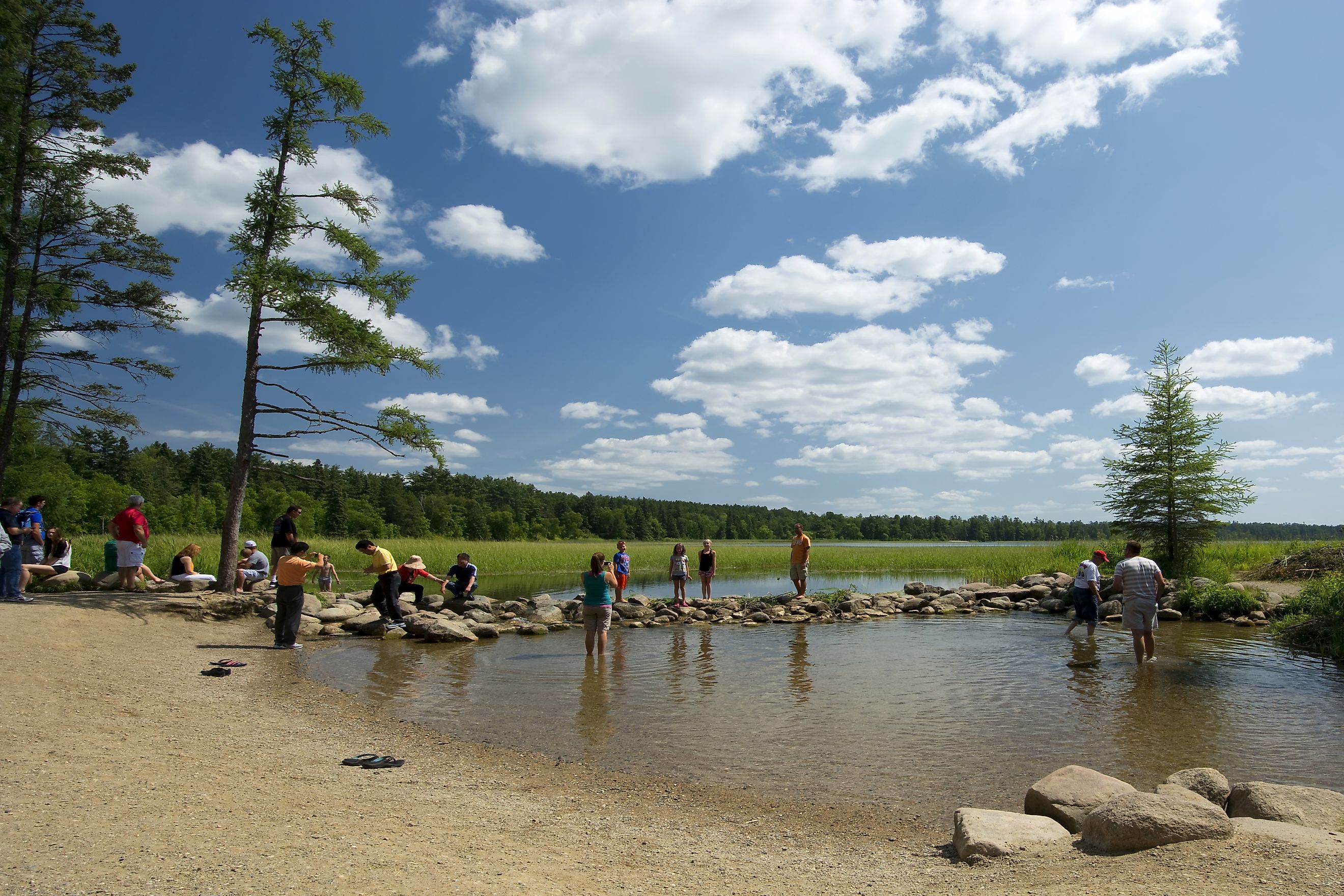
The Mississippi River officially begins at Lake Itasca in Itasca State Park, located in northern Minnesota. At an elevation of approximately 1,475 feet above sea level, Lake Itasca is a modest, glacial lake measuring about 1.8 square miles in size. Despite its small footprint, it is recognized as the headwaters of the fourth-longest river in the world.
The designation of Lake Itasca as the river's source was confirmed in 1832 by Henry Schoolcraft, an American geographer and ethnologist. Before Schoolcraft's exploration, the source of the Mississippi was the subject of speculation and controversy, with various expeditions proposing other nearby lakes and rivers.
From its origins in Lake Itasca, the river begins as a shallow, narrow stream. Visitors to the park can actually walk across the river at its source, where it is only a few feet wide and knee-deep.
A Journey Through America: The River's Course

After leaving Lake Itasca, the Mississippi River flows southward for about 2,340 miles, making it the second-longest river in the United States after the Missouri River. It travels through or along the borders of 10 US states: Minnesota, Wisconsin, Iowa, Illinois, Missouri, Kentucky, Tennessee, Arkansas, Mississippi, and Louisiana.
Along its course, the Mississippi passes through diverse landscapes including dense forests, expansive farmlands, limestone bluffs, industrial centers, and rich wetlands. The river is often divided into three main sections:
-
Upper Mississippi River: From Lake Itasca to the confluence with the Missouri River near St. Louis, Missouri
-
Middle Mississippi River: From St. Louis to the confluence with the Ohio River at Cairo, Illinois
-
Lower Mississippi River: From Cairo to the Gulf of America
Each segment has its own distinct geography, climate, and cultural significance.
Major Cities Along the Mississippi

The river passes through or near many of the United States' major cities, each with a unique relationship to the river:
-
Minneapolis and St. Paul, Minnesota: Known as the Twin Cities, they sit near the upper portion of the river and have long utilized it for transportation, commerce, and recreation.
-
St. Louis, Missouri: Historically one of the most important inland ports, St. Louis became a gateway to the western United States.
-
Memphis, Tennessee: A key location in the cotton trade and a cultural capital for blues and soul music.
-
Baton Rouge, Louisiana: The state capital and a significant industrial and shipping hub.
-
New Orleans, Louisiana: Perhaps the most famous city along the Mississippi, New Orleans was built on the river's delta and has long relied on it for shipping, trade, and culture.
These urban centers developed and flourished in large part due to their strategic positions on the Mississippi River, which facilitated trade, migration, and communication.
The Delta and the Mouth: Where the Mississippi Ends

The Mississippi River ends in Louisiana, where it empties into the Gulf of America. Specifically, the river fans out into the Mississippi River Delta, a vast and complex network of marshes, bayous, and estuaries that covers more than 4,000 square miles.
The river technically has multiple mouths, but the main channel currently empties into the Gulf at Venice, Louisiana, about 95 miles south of New Orleans. This section of the river is called the Birdfoot Delta due to its distinct branching pattern that resembles a bird’s foot from above.
This dynamic area is shaped by sediment deposition, water flow, and the ongoing struggle between land building and coastal erosion. It is ecologically rich but also vulnerable to hurricanes, sea level rise, and human intervention.
Measuring the River: How Long Is the Mississippi?

The official length of the Mississippi River is approximately 2,340 miles, though this number can vary depending on seasonal water levels and shifts in river channels. While it is the second-longest river in the country, it is part of the longest river system in North America when combined with the Missouri River, its primary tributary. The combined Mississippi-Missouri river system stretches over 3,900 miles.
Tributaries and Watershed

The Mississippi River has numerous tributaries that contribute to its size and flow. The Ohio River, joining at Cairo, Illinois, is the largest by volume, often delivering more water than the Mississippi itself at that point. Other major tributaries include:
-
The Missouri River (joins near St. Louis)
-
The Arkansas River (joins in southeastern Arkansas)
-
The Red River (joins in Louisiana)
The entire Mississippi River watershed drains more than 1.2 million square miles, encompassing parts of 31 US states and two Canadian provinces. It is the fourth-largest drainage basin in the world, after the Amazon, Congo, and Nile.
Economic and Cultural Importance

The Mississippi River is essential to the US economy. It supports over 500 million tons of cargo shipped annually, including grain, petroleum, coal, and chemicals. The river is maintained for navigation by a series of locks and dams, especially along the Upper Mississippi.
Beyond commerce, the river has inspired generations of artists, writers, and musicians. From the works of Mark Twain to traditional spirituals and blues music, the Mississippi looms large in American culture.
It is also a vital habitat for countless species of birds, fish, and mammals. The river and its floodplain are home to more than 260 species of fish and provide critical stopover habitat for migrating waterfowl.
Environmental Concerns

Despite its importance, the Mississippi River faces numerous environmental challenges. Agricultural runoff contributes to high levels of nitrogen and phosphorus, which flow into the Gulf of America and cause a seasonal "dead zone" with low oxygen levels. Invasive species such as Asian carp threaten native ecosystems, and climate change is increasing the frequency of flooding events.
There are also longstanding concerns about the loss of wetlands in the river's delta, which serve as natural buffers against hurricanes and support local fisheries.
The River That Connects America

The Mississippi River is more than just a body of water. It is a powerful thread that connects diverse regions, cultures, and ecosystems across the United States. Beginning as a trickle at Lake Itasca and ending in the vast expanse of the Gulf of America, the river is a dynamic force of nature and a lifeline for the millions who live along its banks.
Its journey from source to sea is a reflection of America's own development, challenges, and spirit of resilience. Whether viewed from a canoe in Minnesota, a riverfront park in Memphis, or a levee near New Orleans, the Mississippi continues to shape the land and the lives of those who dwell beside it.