Where is the Continental Divide in the US?
The Continental Divide might sound like something from a geography textbook, but it’s actually a living, breathing part of the American landscape. It's a physical and symbolic spine of the country, running through mountain peaks, national parks, deserts, and alpine lakes. For travelers, hikers, and adventure seekers, the Continental Divide offers some of the most dramatic scenery and meaningful experiences in the entire United States.
So where exactly is the Continental Divide? And what makes it so important? To answer that, we have to head west, gain some elevation, and follow the water.
What Is the Continental Divide?

The Continental Divide is a natural boundary that separates the watersheds that drain into the Pacific Ocean from those that drain into the Atlantic Ocean and Gulf of America. In simpler terms, it's the place where water decides which ocean it’s heading for.
If a raindrop falls just to the west of the divide, it will eventually make its way to the Pacific. If it falls to the east, it’ll journey to the Atlantic or Gulf of America. This hydrological split happens at high elevations, usually in mountain ranges, and forms a continuous line that stretches across the continent.
The Route of the Continental Divide in the US

The Continental Divide runs from the northwestern corner of Montana all the way down to the southwestern tip of New Mexico. It cuts through five US states:
-
Montana
-
Idaho
-
Wyoming
-
Colorado
-
New Mexico
Let’s break it down state by state.
Montana: Where the Divide Enters the US
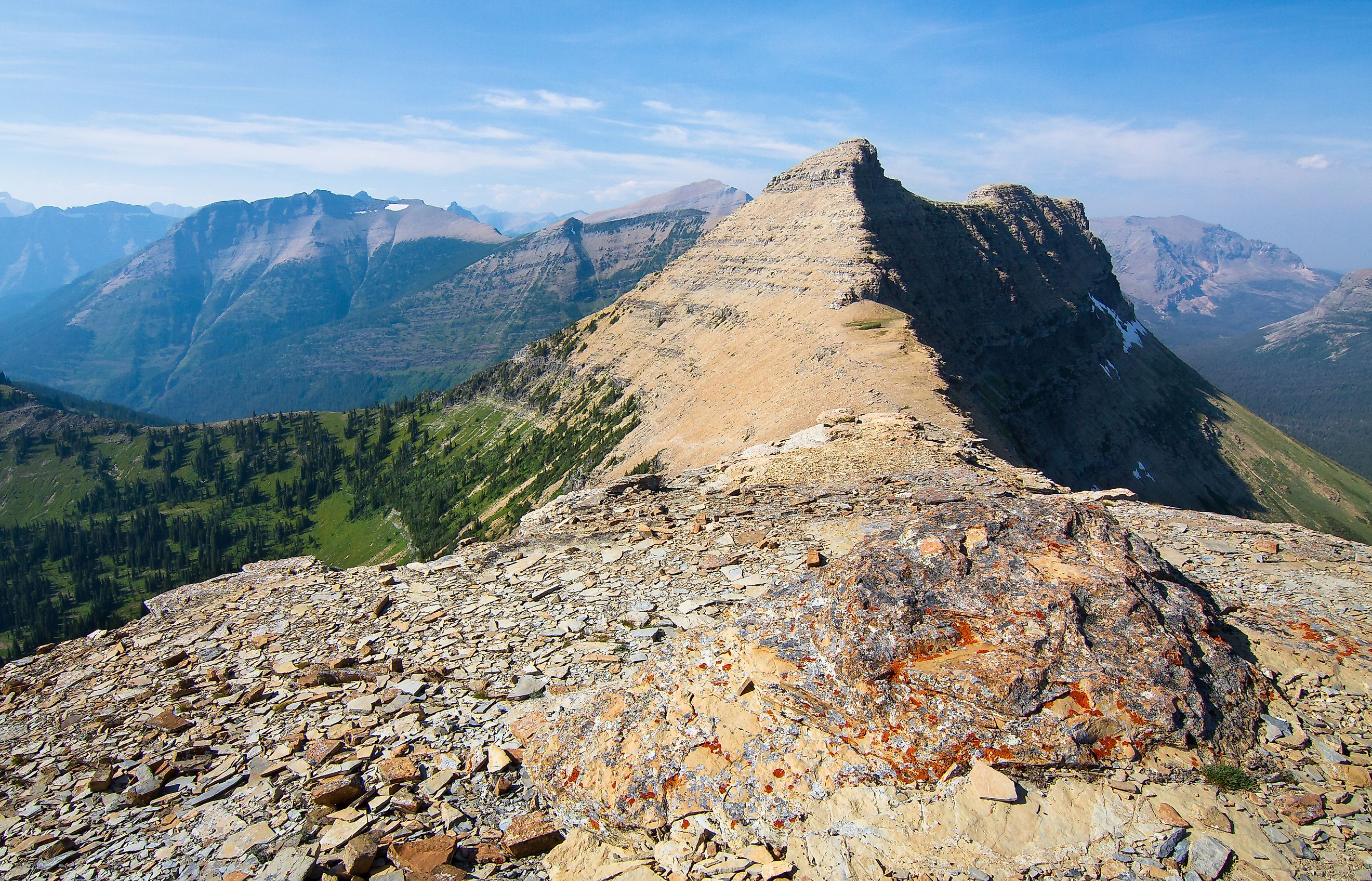
The Divide enters the United States from Canada in northwestern Montana, slicing through Glacier National Park. This is where things get dramatic fast. Towering peaks, glacial valleys, and high mountain passes create a jagged line where east meets west.
In Glacier, you can visit Logan Pass and stand just feet from the divide itself. Hikers on the Highline Trail and Continental Divide Trail (CDT) frequently cross it. Water from the park flows toward the Pacific, the Gulf of America, and Hudson Bay, making it one of the only triple divides on the continent.
Idaho: The Divide Skirts the Border
The Divide briefly traces the border between Montana and Idaho. It weaves through remote wilderness, much of it untouched and rugged. This section of the divide is less visited than the others, but it offers solitude and dramatic beauty for those willing to explore its wild ridgelines and alpine basins.
Wyoming: Yellowstone and the Tetons

Wyoming is home to some of the most iconic Continental Divide landmarks. It enters the state through Yellowstone National Park, one of the most hydrothermally active places on Earth. From there, it meanders through geyser basins, across lakes, and over mountains.
One of the most interesting features in this area is the Parting of the Waters, where Two Ocean Creek splits in two. One fork flows into the Pacific, the other into the Atlantic. It’s a rare, natural hydrologic marvel.
After Yellowstone, the divide climbs into the Wind River Range and through the Red Desert, an elevated desert basin where the divide becomes more subtle. This region surprises many people with its arid, open terrain.
Colorado: The Highest Point of the Divide
If Montana is where the Divide enters the country, Colorado is where it soars to new heights. The Divide crosses through the heart of the Rocky Mountains and reaches its highest point at Grays Peak, elevation 14,278 feet.
Colorado has the longest stretch of the Continental Divide of any state. It bisects the state from north to south and crosses dozens of scenic mountain passes, including Loveland Pass and Monarch Pass. Travelers driving Interstate 70 west of Denver cross the divide at the Eisenhower Tunnel, which sits more than 11,000 feet above sea level.
Hikers can take on the Colorado Trail or sections of the Continental Divide Trail to walk along the spine of the Rockies. Skiers, backpackers, and mountain bikers all follow the Divide as it twists through peaks, valleys, and high-altitude meadows.
New Mexico: Where the Divide Leaves the US
The final leg of the US portion of the Divide cuts through New Mexico before it dips into Mexico. Here, the terrain changes dramatically. The Divide runs through mesas, desert basins, forested hills, and dry plains.
While the elevation is lower, the drama is still high. The Divide traverses the Gila Wilderness, one of the oldest designated wilderness areas in the country. This is where conservationist Aldo Leopold helped shape the modern American conservation movement.
In New Mexico, the Divide is less about jagged peaks and more about sweeping views, big skies, and deep history. This stretch also marks the end of the journey for thru-hikers attempting the entire 3,100-mile Continental Divide Trail.
The Continental Divide Trail

One of the most epic ways to experience the Continental Divide is by hiking the Continental Divide Trail (CDT). This long-distance trail runs roughly 3,100 miles from the Canadian border in Montana to the Mexican border in New Mexico. It passes through national parks, wilderness areas, and some of the most remote terrain in the Lower 48.
The trail is not as developed as the Appalachian or Pacific Crest Trails, but that’s part of its appeal. It offers solitude, wild beauty, and true adventure. Only a few hundred people complete the full CDT each year, but thousands more hike sections of it.
The trail is open to hikers, backpackers, and horseback riders. Certain stretches are also accessible to mountain bikers, depending on local regulations.
Why the Divide Matters

The Continental Divide is not just a line on a map. It plays a major role in shaping ecosystems, weather, and human settlement.
Water Flow
Watersheds on either side of the divide supply water to vast areas of North America. These rivers irrigate farmland, power cities, and support wildlife from the Pacific Northwest to the Gulf Coast.
Climate and Weather
The divide helps separate climatic zones. It often determines where storms drop rain or snow. On the western side, moisture-laden air from the Pacific rises, cools, and drops precipitation. On the eastern side, drier conditions prevail.
Wildlife Corridors
Many animals follow the high ridgelines of the divide during migrations. Protected lands along the divide provide crucial habitat for species like elk, wolves, grizzly bears, and mountain lions.
Human History
Indigenous peoples, explorers, settlers, and traders have used the divide as a route and boundary for centuries. The Lewis and Clark Expedition crossed it in 1805, forever altering the course of American history.
Places You Can Visit the Divide

You don’t have to hike 3,000 miles to enjoy the Continental Divide. Here are some great places to experience it:
-
Glacier National Park, Montana: Hike the Highline Trail or visit Logan Pass.
-
Yellowstone National Park, Wyoming: See the Parting of the Waters or backpack through the Thorofare.
-
Rocky Mountain National Park, Colorado: Drive Trail Ridge Road or hike Flattop Mountain.
-
Loveland Pass, Colorado: One of the easiest ways to drive across the divide at high elevation.
-
Gila National Forest, New Mexico: Explore the Gila Cliff Dwellings and hike in solitude.
Final Thoughts: A Line That Defines a Continent

The Continental Divide is not just a geological curiosity. It is a natural boundary that shapes rivers, climates, ecosystems, and even cultures. Stretching from Montana’s glacier-carved peaks to New Mexico’s sunbaked mesas, it’s a journey through some of the most majestic landscapes in the United States.
For travelers, the Divide offers more than stunning views. It’s a chance to connect with the raw forces that have shaped this continent for millions of years. Whether you stand at a scenic overlook or follow its path for hundreds of miles, the Continental Divide will leave a lasting impression.