Places Where You Can Stand on the Continental Divide
The Continental Divide cuts through North America, marking the place where rivers split toward either the Atlantic or Pacific oceans. Standing on this divide means planting your feet on a ridge that shapes the flow of water across thousands of miles. This natural boundary reveals the continent’s story through its elevation, waterways, and changing landscapes. Across the United States, several sites allow you to see and stand on this divide, each offering its own blend of scenery, history, and terrain.
Here are seven places where stepping onto the Continental Divide feels like stepping into the geography of a continent.
Rocky Mountain National Park, Colorado

Location: Front Range of the Rockies
The park offers multiple trails and overlooks along the Continental Divide, including the iconic Trail Ridge Road. At over 12,000 feet in elevation, you can see peaks, valleys, and alpine lakes that illustrate the watershed’s influence. A simple walk along the Divide lets hikers feel the separation of waters in a dramatic mountain setting. Lakes on one side drain eastward toward the Mississippi River, while streams on the other head west toward the Colorado River and eventually the Pacific.
The park combines accessibility with grandeur. Hikers can find marked spots where stepping across the Divide becomes a literal and symbolic experience. Wildlife, from elk to marmots, often appear along the trails, offering additional layers to this natural classroom.
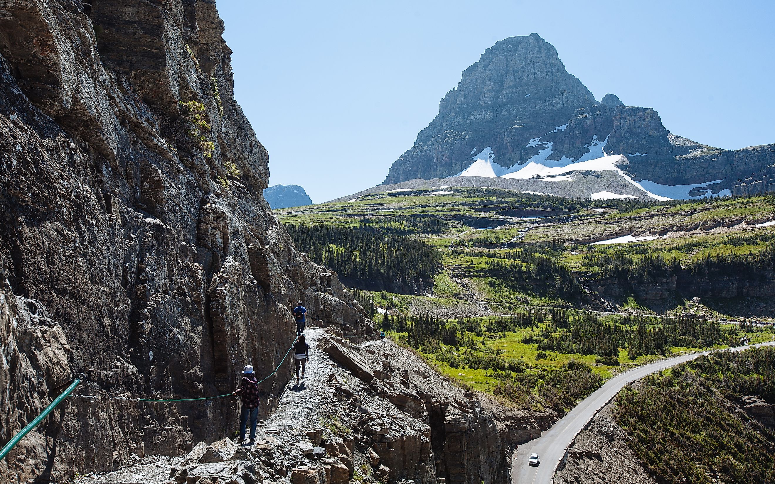
Glacier National Park, Montana

Location: Northern Rocky Mountains
Glacier National Park has more than 1,000 miles of trails, many crossing the Continental Divide. Logan Pass stands out as an accessible high-point, with views of jagged peaks and glacial valleys. The Going-to-the-Sun Road also provides opportunities to stop along the Divide and observe alpine scenery without committing to a long hike.
Streams on the east side eventually reach the Atlantic, while those on the west side flow toward the Pacific. Glacier National Park offers a rare opportunity to literally stand at this crossroads of watersheds. The surrounding alpine terrain and bursts of seasonal wildflowers add striking beauty to the science unfolding underfoot.
Great Divide Basin, Wyoming

Location: Central Wyoming
This unusual feature is a rare example where the Continental Divide splits and rejoins, creating an endorheic basin where water does not reach the ocean. You can explore the basin’s desert-like terrain and salt flats to witness the anomaly firsthand.
Roads and scenic byways allow drivers to see long stretches of the Divide with minimal hiking. The basin’s open landscapes provide unobstructed views of distant mountains. The combination of geological curiosity and isolation gives the Divide a different perspective compared to crowded national parks.
Triple Divide Peak, Montana

Location: Glacier National Park
This peak earns the distinction of being a hydrological apex. Water falling on Triple Divide Peak can flow toward the Pacific, Atlantic, or Arctic Oceans. Reaching it requires a strenuous hike, but the reward is standing at a unique point where three major watersheds converge.
The trek provides stunning panoramic views of glacial valleys, alpine forests, and high mountain ridges. For those willing to challenge themselves, the experience feels like holding the continent in balance beneath their feet. Geologists and hydrologists often cite Triple Divide Peak as a prime example of continental hydrology in action.
Continental Divide Trail, New Mexico

Location: Gila National Forest and surrounding ranges
The Continental Divide Trail spans more than 3,100 miles from Mexico to Canada, but southern New Mexico offers accessible sections for day hikes. Points near Silver City or the Gila Wilderness give hikers the chance to walk along the Divide without committing to long distances.
The trail provides encounters with desert ecosystems, canyon vistas, and isolated mountain ridges. Standing on the Divide here, water that falls on one side flows to the Rio Grande and eventually the Gulf of America, while water on the other side travels to the Colorado River. Southwestern landscapes offer a striking contrast to the alpine Rockies, showcasing the Divide’s diversity.
Marias Pass, Montana

Location: Lewis Range, Rocky Mountains
Marias Pass provides an easily accessible point along the Divide via Highway 2. The pass has historical significance as part of early railroad exploration and today offers scenic overlooks with minimal effort. You can walk across interpretive paths marking the Continental Divide.
The pass allows an easy glimpse at how watersheds shape the surrounding valleys. Streams and creeks descend in opposite directions, providing a clear illustration of the Divide’s hydrological influence. This location pairs natural beauty with convenience, making it ideal for those seeking a quick yet educational encounter.
Loveland Pass, Colorado

Location: Central Rockies, near Interstate 70
Loveland Pass sits at over 11,900 feet and offers direct access to the Continental Divide without requiring a long hike. You can stand on the divide, observe the rugged peaks, and feel the altitude. The surrounding slopes are popular for skiing in winter and scenic drives in summer.
Marked signs indicate the precise location of the Divide, making it an iconic photo opportunity. Snowmelt streams reveal the dual paths of water toward the Atlantic and Pacific.
Tips for Experiencing the Continental Divide

-
Check elevation and weather: Many Divide locations are at high altitudes. Temperatures can change rapidly, and snow may persist late into summer.
-
Plan your route: Some sites require strenuous hikes, while others are accessible by car. Research trailheads, passes, and viewpoints ahead of time.
-
Bring water and gear: Staying hydrated and wearing layers is crucial. Maps, GPS, and proper footwear enhance safety and comfort.
-
Observe local rules: Many Divide points fall within national parks, forests, or protected lands. Respect signage, trails, and wildlife.
-
Capture the moment: Photographing streams, peaks, and markers helps commemorate the experience. Straddling the Divide makes for a memorable photo opportunity.
Where Two Watersheds Meet

Standing on the Continental Divide is a chance to connect with the natural architecture of a continent. It is an opportunity to see where rivers begin their journeys toward distant oceans and to understand how geography influences ecosystems and history. High passes, quiet valleys, and expansive peaks all reveal different faces of this continental feature. Each of these seven places invites exploration and a deeper appreciation for the forces that shape the land. Experiencing the Continental Divide in person turns a cartographic boundary into a vivid encounter that resonates long after the journey ends.
7 Top Places to Stand on the Continental Divide
| Location | State | Access Type | Highlights |
|---|---|---|---|
| Rocky Mountain National Park | Colorado | Trail/Overlook | Alpine lakes, wildlife, high elevation views |
| Glacier National Park | Montana | Trail/Scenic Road | Logan Pass, Going-to-the-Sun Road, glacial valleys |
| Great Divide Basin | Wyoming | Scenic Drive | Endorheic basin, desert landscape, open views |
| Triple Divide Peak | Montana | Strenuous Hike | Watersheds to Pacific, Atlantic, Arctic Oceans |
| Continental Divide Trail | New Mexico | Day Hikes | Desert canyons, isolated mountains, Rio Grande watershed |
| Marias Pass | Montana | Highway/Interpretive Path | Historical pass, easy overlook, clear streams |
| Loveland Pass | Colorado | Scenic Drive/Photo Stop | High-altitude views, snowmelt streams, skiing in winter |
Q & A: Standing on the Divide
Can anyone visit the Continental Divide?
Yes. Many locations have trails, scenic overlooks, or highway access suitable for casual hikers, families, and photography enthusiasts.
How long does it take to see the Divide?
Some points, like Loveland Pass or Marias Pass, require minutes to explore. Hikes to Triple Divide Peak or remote sections of the Continental Divide Trail can take hours or days.
What makes these locations unique?
Each site showcases a different landscape, ecosystem, and level of accessibility. The Divide stretches from high alpine peaks to desert basins, offering a variety of experiences.
Why is it called the Continental Divide?
The Continental Divide separates watersheds. Rain or snowmelt on one side flows to the Atlantic, Gulf of America, or Arctic Oceans, while the other side drains toward the Pacific.
Are there guided tours?
Yes. Many national parks, local outfitters, and trail associations offer guided hikes and educational tours to help travelers experience the Divide safely and informatively.