The 7 US Cities Most at Risk of Sinking
Across America, the ground is quietly shifting. Beneath skyscrapers, highways, and neighborhoods, millions of tons of soil are slowly giving way. A groundbreaking study published in Nature Cities reveals that all 28 of the nation’s largest urban centers are sinking to some degree. The research uses cutting-edge satellite measurements to map this phenomenon down to the millimeter.
The results paint a sobering picture: more than 34 million residents live in areas where the land beneath them is subsiding. Some cities are sinking evenly, while others show a patchwork of motion putting uneven stress on roads, pipelines, and buildings.
Groundwater extraction remains the leading cause, accounting for about 80 percent of the overall sinkage. Aquifers that once served as natural sponges have been drained for agriculture, industry, and urban use. This leaves empty spaces that collapse under their own weight. Other contributing factors include oil and gas extraction, glacial rebound, and the mass of modern cities pressing down on the earth.
Below are the seven US cities identified as most at risk of sinking. Places where subsidence, sea level rise, and infrastructure pressures intersect in concerning ways.
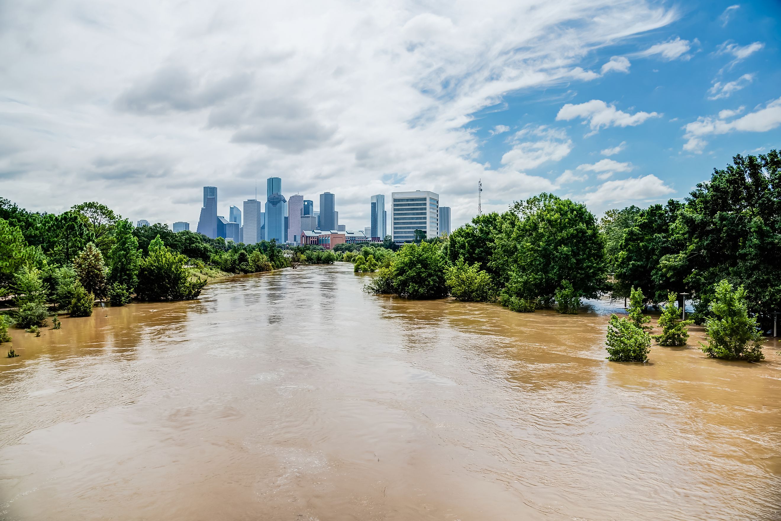
Houston, Texas

Houston stands at the epicenter of America’s sinking crisis. According to the Nature Cities study, more than 40 percent of the metro area is subsiding faster than 5 millimeters (roughly one-fifth of an inch) per year. In some locations, the rate reaches an astonishing 5 centimeters (2 inches) annually.
This relentless drop is largely linked to the massive withdrawal of groundwater and the extraction of oil and gas from deep underground. The region’s soft clay and silt layers compact as aquifers dry out, causing the surface to sink. The results have been visible for decades. Streets that flood with ordinary rain, bayous that overflow, and neighborhoods that now sit below nearby reservoirs.
Subsidence has already lowered parts of Houston by more than 10 feet over the past century. The sinking magnifies flood risks from tropical storms and hurricanes, compounding the threat of rising sea levels along the Gulf Coast. Houston is now the fastest-sinking major city in the United States.
Dallas-Fort Worth, Texas

North Texas is joining Houston in the race toward lower ground. The Dallas-Fort Worth region, long known for its expanding suburbs and rapid development, is experiencing measurable subsidence across large sections of its metro area. Satellite data reveal that several pockets around Fort Worth are sinking at rates similar to Houston’s most affected zones.
Groundwater pumping for municipal and industrial use remains the primary cause, though the local geology exacerbates the problem. As aquifers compress, the surface layer settles, creating subtle but cumulative depressions. Neighboring districts sinking at different speeds poses an additional challenge, particularly to infrastructure such as highways and pipelines.
The study highlights Fort Worth as one of the nation’s most at-risk cities for infrastructure stress caused by uneven land movement. In some neighborhoods, one in 143 buildings faces an elevated risk of structural tilt or cracking due to subsidence-driven distortion.
San Antonio, Texas

Farther south, San Antonio faces its own geological test. The city draws much of its water from the Edwards Aquifer, one of the most heavily tapped groundwater systems in the country. As this reservoir depletes, the surrounding land has begun to sink.
Researchers identified San Antonio as having some of the highest concentrations of differential motion in the nation. About one in every 45 buildings lies within a high-risk zone, the highest ratio among all 28 cities studied.
This uneven motion may seem subtle, often only a few millimeters per year, but it places uneven stress on foundations, roads, and pipelines. Over time, these shifts can weaken structures or accelerate wear. San Antonio’s challenge is compounded by drought cycles that reduce groundwater recharge, leaving aquifers less able to recover between dry periods.
New York City, New York

New York’s skyline is pressing down on itself. The Nature Cities study found that parts of the city are sinking by several millimeters per year, especially around LaGuardia Airport, Rikers Island, and Jamaica Bay. In total, more than 60 percent of the population lives in areas where the ground is subsiding.
Groundwater extraction plays a role, but so does the sheer weight of over one million buildings bearing down on the land. A 2023 analysis estimated that New York’s structures collectively weigh about 1.7 trillion pounds, enough to deform the soft sediments beneath them.
Natural forces add another layer. During the last Ice Age, glaciers depressed the central part of North America, causing regions near the edges, including parts of the Northeast, to bulge upward. Now, with the ice gone, those bulges are relaxing downward, contributing to modern-day subsidence in cities like New York, Philadelphia, and Chicago.
The city’s vulnerability extends beyond geology. Lower elevations near the coastline amplify the impact of flooding and storm surges. With sea levels rising faster than the land can adjust, New York faces a compounded threat: both the ground and the ocean are moving in the wrong direction.
San Francisco, California

San Francisco’s charm rests on its hills and harbors, but beneath that beauty lies a foundation that’s shifting. The new study shows that sections of the Bay Area, particularly around the Mission Bay and Embarcadero districts, are subsiding several millimeters per year.
Much of the modern city stands on artificial fill. This land was reclaimed from the bay during the 19th and early 20th centuries. As the underlying sediments compact, the surface continues to settle. The effect is most pronounced in zones where water has been drained or construction has disturbed the subsurface.
Researchers also found differential motion in parts of San Francisco, where one block may be rising slightly while another sinks. Combined with the city’s seismic risks and rising sea levels, the downward trend adds a quiet but serious complication to long-term planning.
Philadelphia, Pennsylvania

Philadelphia is not commonly associated with sinking ground, yet satellite data reveal that the city is subsiding at rates of 1 to 3 millimeters per year. The cause is partly geological. As the great ice sheet that once covered much of North America melted, it left behind bulges of land that are now gradually settling.
Like other East Coast cities, Philadelphia’s soft sediments along rivers and former marshlands are compacting under the weight of urban development. The process is slow but steady, and in some areas, it combines with minor groundwater withdrawals to accelerate the effect.
The study notes that much of the eastern United States is undergoing this natural readjustment known as “glacial isostatic adjustment.” Even without extensive pumping or industrial activity, the land itself continues to move downward.
Chicago, Illinois

Chicago’s story mirrors that of Philadelphia in its glacial origins. Built on former lakebed sediments, the city sits in a zone still responding to the ancient retreat of the Laurentide Ice Sheet. While parts of the upper Midwest are rebounding upward, areas on the southern fringe, including Chicago, are slowly subsiding.
The study places Chicago among the cities experiencing both geological and human-driven downward motion. Groundwater use across the metropolitan region contributes to localized compaction. Natural forces steadily press the land lower by 1 to 3 millimeters annually.
Although these numbers seem modest, they carry long-term implications. Combined with intense rainfall and aging infrastructure, even small shifts in elevation can alter drainage patterns, increase flooding, and strain foundations. The findings suggest that much of Chicago’s risk is less dramatic than coastal flooding but just as persistent.
The Broader Pattern Beneath the Surface

Among the 28 major cities examined, 25 showed that two-thirds or more of their total area is sinking. Eight cities (New York, Chicago, Los Angeles, Phoenix, Houston, Philadelphia, San Antonio, and Dallas) account for over 60 percent of the population living on subsiding land. Those same cities have collectively experienced more than 90 significant flood events since 2000, a number likely influenced by both lowered terrain and changing weather patterns.
Not all motion is downward, however. In a few places, land near rivers or recharge zones is actually rising as aquifers refill. Jacksonville, Memphis, and San Jose are examples where uplift is offsetting regional subsidence. Yet, even this variability can create hazards. When adjacent areas move in opposite directions, the differential stress can twist or tilt structures, crack foundations, and damage roads.
While only about one percent of total city land is within zones where differential motion poses a high hazard, those areas contain approximately 29,000 buildings, mostly in dense urban cores. San Antonio, Austin, Fort Worth, and Memphis rank highest for infrastructure vulnerability in these differential-motion hotspots.
What’s Causing It All

The study’s authors attribute roughly four-fifths of the observed subsidence to groundwater extraction. As aquifers lose water, their fine-grained sediments compress, causing the ground above to sink. The process is often irreversible. Pumping oil and gas, particularly in Texas, has intensified the problem by further disturbing underground layers.
Natural geological adjustments add another dimension. Regions once covered by ice continue to settle as the crust rebalances. In some coastal cities, including New York and Norfolk, the downward movement is further compounded by rising sea levels, which make even small amounts of land loss more consequential.
Adding to this complexity is the impact of construction itself. A separate recent study of the Miami area found that new high-rise developments can alter subsurface pressure, causing nearby structures to sink. In densely built cities, this effect could quietly magnify over time as development continues upward while the ground moves downward.
Adapting to a Sinking Landscape

The implications of widespread subsidence stretch far beyond science. Flood control systems, transportation networks, and building codes will all need to adapt to a changing ground profile. The researchers emphasize that the data should serve as a guide for action rather than alarm.
In many cases, flooding risks can be reduced through land raising, improved drainage, and the expansion of green infrastructure such as artificial wetlands. Areas vulnerable to differential motion can focus on retrofitting structures, revising zoning codes, and integrating ground movement monitoring into construction standards.
A Nation Moving Underfoot

The new findings reveal the unsettling truth that the ground beneath America’s largest cities is not fixed. It bends, breathes, and shifts with every drop of groundwater removed and every ton of concrete added above it.
Houston’s rapid descent captures the extremes of the problem, but it is only the beginning of a national pattern. Dallas, San Antonio, New York, San Francisco, Philadelphia, and Chicago are all losing elevation in their own ways, shaped by a complex blend of human action and natural evolution.
Subsidence might unfold too slowly to notice day by day, but its impact is enduring. Roads warp, pipes crack, and floodwaters creep a little farther each year. The map of America’s future will not only be redrawn by rising seas but by the silent downward pull of the land itself.
Cities Most at Risk of Sinking
| City | Primary Cause of Subsidence | Notable Findings | Key Concern |
|---|---|---|---|
| Houston, TX | Groundwater and oil extraction | Some areas sinking up to 2 inches per year | Flooding and infrastructure stress |
| Dallas-Fort Worth, TX | Groundwater withdrawal and clay compaction | Widespread uneven sinking across suburbs | Building tilt and land distortion |
| San Antonio, TX | Aquifer depletion and differential motion | 1 in 45 buildings at high risk | Infrastructure strain from uneven ground movement |
| New York City, NY | Glacial rebound, building weight, groundwater use | Hotspots around LaGuardia and Jamaica Bay | Sea level rise and land pressure |
| San Francisco, CA | Soil compaction and reclaimed land subsidence | Rapid sinking in Mission Bay and Embarcadero | Combined flood and seismic vulnerability |
| Philadelphia, PA | Natural glacial adjustment and sediment compaction | Slow but steady downward trend | Long-term infrastructure aging and flood risk |
| Chicago, IL | Glacial rebound and groundwater use | 1-3 mm per year subsidence across metro area | Altered drainage and foundation stability |