Mount Mitchell: The Tallest Peak East of the Mississippi River
If you have ever driven the Blue Ridge Parkway and spotted a mountain that seems to rise above all the rest, there is a good chance you were looking at Mount Mitchell. Standing 6,684 feet above sea level, it is the highest point in mainland North America east of the Mississippi River. This North Carolina giant is not just a mountain. It is a living piece of history, a place of rugged beauty, and a challenge for both nature and the people who have sought to measure, climb, and protect it.
From its role in Cherokee culture to its place as a modern hiking and sightseeing destination, Mount Mitchell has a story that stretches across centuries. Whether you want to know how it got its name, what grows at the summit, or how cold it gets in winter, this peak delivers more than just sweeping views.
Where to Find Mount Mitchell

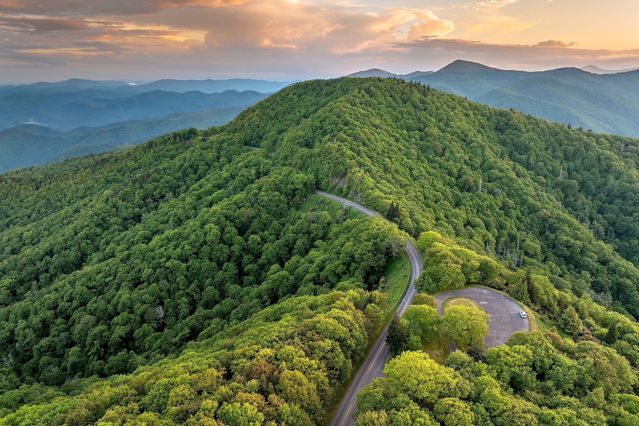
Mount Mitchell sits in the Black Mountain subrange of the Appalachian Mountains, about 19 miles northeast of Asheville, North Carolina. It is part of Mount Mitchell State Park and surrounded by the Pisgah National Forest. Visitors often combine a trip to the summit with a drive along the scenic Blue Ridge Parkway, which connects to the mountain via NC Highway 128. The road climbs almost to the top, ending in a parking area where a short but steep paved trail leads to the summit observation deck.
The location offers a unique vantage point over the Southern Appalachians. On a clear day, you can see deep blue ridges fading into the distance in every direction. This is also a place where the air feels different. At over 6,600 feet, the summit climate is more like southeastern Canada than the American South.
A Mountain of Superlatives

Mount Mitchell is a mountain of records and superlatives. It is the highest peak east of the Mississippi River and the second-highest point in eastern North America south of the Arctic Cordillera. Its nearest higher neighbor is more than 1,100 miles away in Colorado.
For a brief period in early American history, Mount Mitchell was considered the tallest mountain in the entire United States. This lasted from 1789 until 1803, when the Louisiana Purchase brought the much higher Rocky Mountain peaks into US territory.
Its topographic isolation and towering profile make it an icon for the region. That isolation also means the mountain has its own weather patterns, sometimes wildly different from the valleys below.
The Cherokee and the Naming of Mount Mitchell

Long before European settlers arrived, the Cherokee people called the mountain Attakulla. It was a place woven into their homeland, surrounded by forests rich with game, edible plants, and medicinal herbs.
In the early 1800s, European-American settlers called the mountain Black Dome for its rounded, dark silhouette. Its modern name honors Elisha Mitchell, a professor at the University of North Carolina who measured the mountain in the 1830s and determined it was taller than Mount Washington in New Hampshire, which was widely believed to be the highest peak in the East at the time.
Tragically, Mitchell died in 1857 after falling near what is now known as Mitchell Falls while attempting to confirm his earlier measurements. He is buried at the summit he helped make famous.
How to Reach the Summit

You do not need to be a professional mountaineer to reach the top of Mount Mitchell. A 4.6-mile spur road from the Blue Ridge Parkway, NC 128, takes you almost all the way there. From the parking area, a paved 980-foot trail leads to the observation deck. The climb is short but steep, and at this elevation the thinner air can make it feel more strenuous.
For those who prefer a hiking challenge, the Mount Mitchell Trail offers an 11.4-mile round trip with an elevation gain of over 3,600 feet from the Black Mountain Campground. This route tests your endurance but rewards you with sweeping views and a sense of achievement few roadside visitors experience.
The current observation deck, completed in 2009, provides a 360-degree view over the ridgelines and valleys of the Appalachians.
Geology and Soils

Mount Mitchell’s story began more than a billion years ago. The mountain formed during the Precambrian era, when ancient marine deposits transformed into gneiss and schist through heat and pressure. These rocks were later uplifted during the Alleghenian orogeny, a massive mountain-building event that created much of the Appalachian range.
The summit soils are well-drained and stony, with textures ranging from sandy clay loam to loam. These conditions support specialized plant communities adapted to the high-elevation environment.
Life at the Top: Flora and Fauna

The summit is home to a dense stand of Southern Appalachian spruce-fir forest. Two evergreen species dominate here, the red spruce and the Fraser fir. Sadly, most mature Fraser firs were lost in the late 20th century to the non-native balsam woolly adelgid.
Despite these losses, young fir and spruce trees thrive in the subalpine climate. Summer brings an abundance of wildflowers, along with blueberries and blackberries that feed both birds and hikers. The mountain’s cooler temperatures allow plants more typical of Canada to flourish here in the southern United States.
Birdwatchers often spot species such as the winter wren, red-breasted nuthatch, and black-capped chickadee. The cool, moist conditions also support rare salamanders and mosses.
Weather and Climate Extremes

Mount Mitchell’s climate is classified as warm-summer humid continental. Winters are long and cold, with the average January temperature just above 25 degrees Fahrenheit. Summers are mild, with July averaging below 60 degrees Fahrenheit at the summit.
The mountain holds the North Carolina record for coldest temperature ever recorded, a bone-chilling minus 34 degrees Fahrenheit in January 1985. High winds are common, with gusts recorded at up to 178 miles per hour.
Precipitation is abundant year-round, averaging more than 80 inches annually. Snow is frequent from December through March, with historic storms dropping several feet at a time. In 2018, Mount Mitchell recorded nearly 140 inches of total precipitation, the highest annual total ever measured east of the Cascade Range.
Conservation and Challenges

Mount Mitchell’s beauty hides a fragile ecosystem. Airborne pollution, including acid rain, has damaged its spruce-fir forest by leaching important minerals from the soil and releasing harmful metals such as aluminum. Because much of this pollution arrives from hundreds of miles away, reducing the impact requires broad regional cooperation.
State park protections and ongoing conservation efforts aim to preserve both the mountain’s natural habitats and its accessibility for visitors. While some damage is irreversible, reforestation projects and stricter air quality standards offer hope for the future.
Things to Do Around Mount Mitchell

A trip to Mount Mitchell is not just about standing at the highest point. The surrounding region offers hiking, picnicking, photography, and seasonal events. In autumn, the fall foliage creates a dazzling mix of red, orange, and gold across the ridgelines. In spring and summer, wildflowers blanket the slopes.
Popular trails include the Deep Gap Trail, which leads from the summit to nearby peaks such as Mount Craig, the second-highest point in the East. The Balsam Nature Trail offers a short loop through the spruce-fir forest for those seeking a gentler walk.
Birdwatching, stargazing, and even snowshoeing in winter are also possible for those prepared for the conditions.
Visiting Tips

-
Dress in layers: Temperatures at the summit are often 20 to 30 degrees cooler than surrounding areas.
-
Start early: Afternoon clouds and thunderstorms are common in summer.
-
Stay hydrated: Even short walks can feel harder at high elevations.
-
Check weather forecasts: Snow, ice, and fog can occur at any time of year.
-
Respect the environment: Stay on marked trails to protect fragile alpine vegetation.
Why Mount Mitchell Matters
Mount Mitchell is more than just a geographic high point. It is a place where history, science, and natural beauty meet. The Cherokee saw it as part of their cultural landscape. Elisha Mitchell gave his life to prove its height. Today, scientists study its changing ecosystems while thousands of visitors each year simply marvel at the view.
Standing at the summit, surrounded by ridges fading into blue haze, you can feel the pull of the place. It is a reminder that even in the busy modern world, some heights remain wild and unspoiled.
From its deep geological roots to its lofty summit winds, Mount Mitchell is a mountain worth knowing, exploring, and protecting. Whether you arrive by hiking boot or by car, the tallest peak east of the Mississippi offers a high point in every sense of the word.