The Widest Rivers in the United States
When you picture a river, you might imagine a narrow ribbon of water cutting through a valley or winding past a small town. But across the United States, certain rivers reach astonishing widths, becoming massive bodies of water that look more like inland seas than flowing channels. These vast waterways are some of the most powerful and dynamic features of the American landscape.
Some of these rivers are naturally wide due to the flat terrain they flow through. Others swell with seasonal runoff or expand within massive floodplains. Whether shaped by nature or modified by reservoirs and tidal forces, these rivers are both essential and extraordinary. They influence commerce, agriculture, culture, and geography across the regions they traverse.
Here are the widest rivers in the United States and what makes each one remarkable.
Mississippi River

Maximum Width: Over 11 miles (Lake Pepin, Minnesota)
Average Width: 1 to 3 miles in southern stretches
Length: 2,340 miles
States Touched: Minnesota, Wisconsin, Iowa, Illinois, Missouri, Kentucky, Tennessee, Arkansas, Mississippi, Louisiana
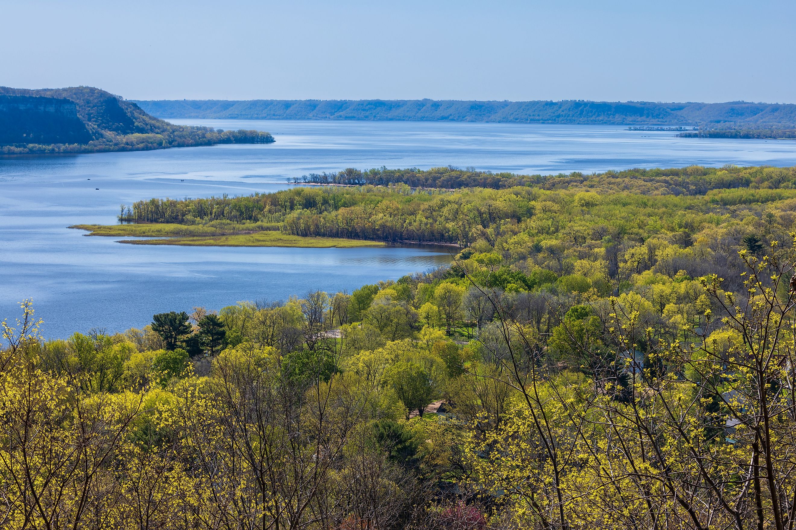
The Mississippi River is one of the most iconic rivers in the world and the widest in the United States. Its broadest point occurs at Lake Pepin, a natural widening between Minnesota and Wisconsin where the river stretches over 11 miles across.
Downstream, particularly in the Mississippi Delta and near Baton Rouge, the river regularly spans 1 to 3 miles wide. During major flood events, it has been known to double or triple in size. These floodplains are essential to the river's natural cycle and play a crucial role in regional agriculture and water management.
The Mississippi serves as a major artery for transportation and commerce and remains one of the most significant natural features of the central United States.
Missouri River

Maximum Width: Up to 10 miles during flood conditions
Average Width: 1,000 to 2,500 feet
Length: 2,341 miles
States Touched: Montana, North Dakota, South Dakota, Nebraska, Iowa, Kansas, Missouri
The Missouri River is the longest river in North America, slightly edging out the Mississippi in length. Though typically narrower than its southeastern counterpart, the Missouri can grow astonishingly wide during floods, with some sections reaching up to 10 miles across.
Its route through the Great Plains contributes to its width, especially where the terrain is flat and the water has space to spread. Reservoirs such as Lake Sakakawea and Fort Peck Lake also contribute to the river's wider stretches. These features create massive open-water areas that resemble inland lakes.
The Missouri has long been a critical source of water, irrigation, and transportation across the western and central United States.
Ohio River

Maximum Width: Up to 1 mile
Average Width: 0.5 to 1 mile
Length: 981 miles
States Touched: Pennsylvania, Ohio, West Virginia, Kentucky, Indiana, Illinois
Forming the natural boundary between several Midwestern and Southern states, the Ohio River is a consistently wide waterway throughout its length. From Pittsburgh to its confluence with the Mississippi, the river maintains an average width of about half a mile, with many sections stretching to a full mile across.
Major cities like Cincinnati, Louisville, and Evansville rely on the Ohio River for commerce and industry. Its wide channel supports heavy barge traffic and forms an essential link between the interior United States and the Gulf of America via the Mississippi River.
Due to its steady and navigable breadth, the Ohio is considered one of the most commercially important rivers in the eastern United States.
Yukon River

Maximum Width: Up to 3 miles
Average Width: 1 to 2 miles
Length (US Portion): Approximately 1,980 miles
States/Territories Touched: Alaska, Yukon (Canada)
The Yukon River flows through some of the most remote and pristine wilderness in North America. In Alaska, this powerful river frequently exceeds two miles in width and reaches up to three miles across in places like Galena.
The Yukon's massive volume is fed by glacial melt and heavy seasonal precipitation. It winds through low-lying tundra and boreal forests, creating broad floodplains and complex braided channels. In summer, the river swells with runoff, and in winter, it freezes over and becomes a highway for snowmobiles and sled dog teams.
Its width and wilderness make the Yukon a lifeline for remote communities and a vital part of Alaska's environmental and cultural identity.
Columbia River

Maximum Width: Over 3 miles
Average Width: 1 to 2 miles
Length: 1,243 miles
States Touched: Washington, Oregon (originates in British Columbia, Canada)
The Columbia River is the largest river in the Pacific Northwest and one of the widest along the West Coast. Near its mouth at Astoria, Oregon, it opens up to more than 3 miles across before meeting the Pacific Ocean.
Even inland, the Columbia maintains significant width through major dammed sections such as Bonneville Reservoir and Lake Celilo. These artificial lakes expand the river’s surface area while regulating flow and generating hydroelectric power.
The Columbia has carved dramatic landscapes along its path, including the Columbia River Gorge, and serves as an international boundary in some areas. Its size and width are matched by its cultural, ecological, and economic importance.
St. Lawrence River

Maximum Width: Over 2 miles
Average Width: 1 to 2 miles
Length (US Portion): Approximately 114 miles
States/Territories Touched: New York, Quebec, Ontario
Flowing from Lake Ontario to the Atlantic Ocean, the St. Lawrence River is one of North America’s greatest waterways. While most of the river flows through Canada, its US stretch along the New York border features significant width, regularly exceeding 1 mile and reaching over 2 miles in places such as the Thousand Islands region.
The river forms part of the international boundary and is an essential component of the St. Lawrence Seaway, which allows ocean-going ships to travel deep into the North American interior. The broad and deep waters of the St. Lawrence are home to diverse aquatic ecosystems and are lined with a mix of forests, towns, and historical sites.
Hudson River

Maximum Width: Over 3 miles (Tappan Zee)
Average Width: 0.5 to 2 miles
Length: 315 miles
State Touched: New York
The Hudson River is a tidal estuary for much of its length, and this tidal influence helps it achieve dramatic widths. Near the Tappan Zee Bridge, the river stretches over 3 miles from bank to bank. Even north of that point, through the Hudson Valley and up toward Albany, the river remains consistently broad.
The Hudson is both scenic and strategic. It supported early American trade and transport, and today it continues to play a major role in maritime commerce, especially in the New York Harbor area. Its width also makes it a popular waterway for recreational boating, rowing, and sightseeing cruises.
From the Palisades to the Catskills, the Hudson’s broad channel flows through some of the Northeast's most iconic scenery.
Atchafalaya River

Maximum Width: Up to 1.5 miles in the delta
Average Width: 0.5 to 1 mile
Length: 137 miles
State Touched: Louisiana
The Atchafalaya River flows through southern Louisiana and carries water from both the Mississippi and Red Rivers. Although shorter than many major rivers, it is exceptionally wide, particularly in the Atchafalaya Basin where it forms one of the largest river deltas in the country.
This region is a vast wetland system that lacks sharply defined riverbanks. Instead, the water spreads across swamps, bayous, and forested floodplains. During high-water seasons, the river can reach over 1.5 miles in width, covering thousands of acres with slow-moving water.
The Atchafalaya supports rich biodiversity and is a key part of Louisiana’s environmental fabric. It also plays a vital role in flood control and sediment delivery to the Gulf of America.
Summary Table: Widest Rivers in the US
| River | Maximum Width | Primary Location |
|---|---|---|
| Mississippi | 11+ miles | Minnesota to Louisiana |
| Missouri | 10+ miles (flood) | Montana to Missouri |
| Ohio | ~1 mile | Pennsylvania to Illinois |
| Yukon | 3+ miles | Alaska |
| Columbia | 3+ miles | Washington and Oregon |
| St. Lawrence | 2+ miles | New York (border with Canada) |
| Hudson | 3+ miles | New York |
| Atchafalaya | 1.5+ miles | Louisiana |
Where America’s Rivers Reach Their Fullest Span
Rivers have always played a defining role in shaping American life, but it is not just their length or depth that makes them remarkable. Their width can also be a symbol of strength, history, and complexity. From the Mississippi’s sweeping Lake Pepin to the icy expanse of the Yukon, these rivers offer scale that commands attention.
Their vast widths support industries, wildlife, recreation, and entire communities. They carry stories as well as water, forming natural corridors that connect cities, ecosystems, and people. Whether viewed from a bridge, a boat, or a satellite image, the widest rivers in the United States remind us of the incredible power and diversity of the nation's waterways.