Which US States Are Part of Tornado Alley?
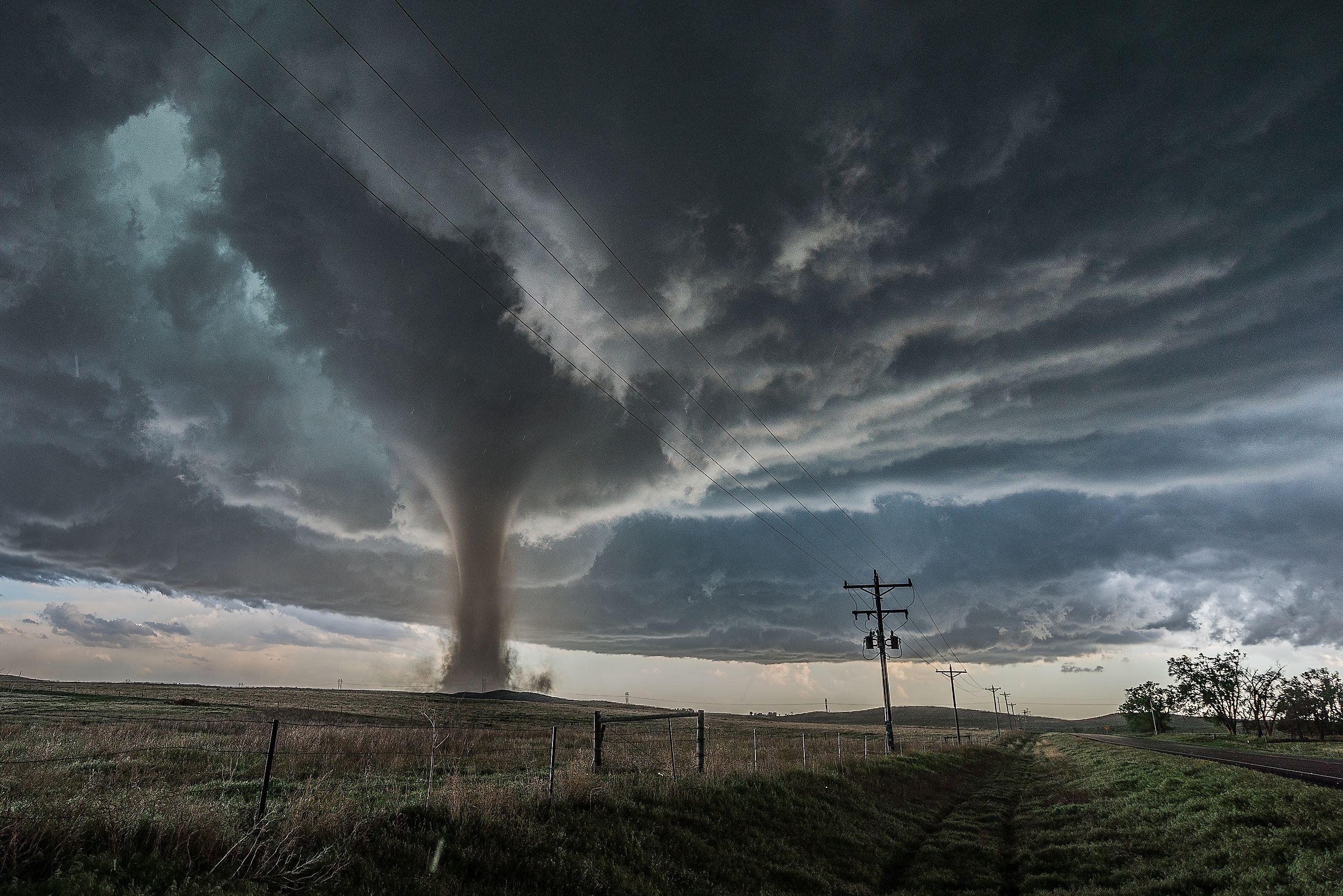
Few natural events capture both fear and fascination like tornadoes. These swirling columns of wind can rip across open plains or small towns with astonishing speed and force. For decades, Americans have referred to the region most prone to these storms as “Tornado Alley.” But what exactly defines Tornado Alley, and which states fall inside it?
The answer is not as simple as it seems. Meteorologists debate the exact boundaries of this region, and in recent years, shifts in storm patterns have raised new questions about whether Tornado Alley is moving. Still, a core group of states remains synonymous with tornado activity, and they are central to understanding the geography, climate, and culture of severe weather in the United States.
Take a look at the seven states commonly included in Tornado Alley, why the region is so vulnerable, and the unique relationship these states have with some of the most dramatic weather on earth.
What Is Tornado Alley?

“Tornado Alley” is not an official scientific designation. Instead, it is a widely used nickname for the central region of the United States where tornadoes are most frequent and often most powerful. The term became popular in the mid-20th century when researchers and the media began mapping tornado activity across the Great Plains.
The region is shaped by geography and weather patterns. Warm, humid air flowing north from the Gulf of America collides with dry air sweeping east from the Rocky Mountains and cold fronts dropping south from Canada. This recipe creates powerful thunderstorms capable of spawning tornadoes.
Meteorologists generally agree that Tornado Alley stretches from northern Texas through the central Plains and into parts of the Midwest. While its borders are blurry, the states at its heart have been hit time and again by severe outbreaks.
The Core States of Tornado Alley
Texas

No state records more tornadoes annually than Texas. Its massive size means it encompasses a wide range of climates, but the northern and central regions, including the Panhandle and the Dallas-Fort Worth area, see the highest concentration. On average, Texas experiences over 140 tornadoes each year.
The Red River Valley and areas stretching toward Oklahoma are especially prone, and towns like Wichita Falls have seen devastating storms. Texas’ role in Tornado Alley is so significant that many experts consider it the starting point of the corridor.
Oklahoma
Oklahoma is often considered the heart of Tornado Alley. Its flat terrain and central location in the clash zone of warm Gulf air and cold Canadian fronts make it extremely vulnerable. The state averages about 60 tornadoes per year, but it is famous for their intensity.
The city of Moore, just south of Oklahoma City, has been struck by multiple violent tornadoes in recent decades, including EF5 storms in 1999 and 2013. The state also hosts the National Weather Center in Norman, making it a hub for tornado research and forecasting.
Kansas

Kansas is so synonymous with tornadoes that it became part of American pop culture through “The Wizard of Oz.” The state averages roughly 90 tornadoes a year, ranking among the highest in the nation. Central and southern Kansas see the most activity, particularly in spring and early summer.
Notably, Kansas holds the record for the most tornadoes in a single year, with 187 reported in 2008. Wide-open plains and dryline clashes make Kansas one of the most iconic Tornado Alley states.
Nebraska
Nebraska sits in the northern stretch of Tornado Alley. The state averages around 50 tornadoes annually, with the central and eastern parts seeing the highest numbers. The geography of Nebraska plays a crucial role, as warm air from the Gulf meets colder northern air over its flat terrain.
One of the most famous tornado events in state history was the 1980 Grand Island outbreak, which produced seven tornadoes that struck the city in one night. The unusual storm highlighted just how dangerous Nebraska’s location can be.
South Dakota

South Dakota, though less frequently mentioned, sits firmly on the northern edge of Tornado Alley. The state averages around 30 tornadoes per year, primarily in the eastern plains. While many are weaker, South Dakota has recorded powerful storms, including EF4 events.
Because of its location, tornadoes here often develop later in the season compared to the southern Plains, extending Tornado Alley’s reach into early summer.
Iowa
Iowa lies at the crossroads of Tornado Alley and the Midwest’s broader tornado-prone areas. The state experiences about 50 tornadoes annually, with activity concentrated in the central and southern counties.
The 2008 Parkersburg tornado, an EF5, remains one of the most destructive in Iowa’s history, leveling large parts of the town. The state’s agricultural landscape makes tornadoes particularly costly, as storms often destroy crops and farm structures.
Missouri

Missouri is another key state in Tornado Alley, especially in the western and central regions. The state averages about 45 tornadoes per year. Its location at the meeting point of the Plains and the Midwest puts it at risk for both spring and fall tornado seasons.
The city of Joplin suffered one of the deadliest tornadoes in US history in 2011, when an EF5 storm struck, killing over 150 people. Events like this cement Missouri’s place in Tornado Alley.
Other States Sometimes Included
While the core states make up the traditional Tornado Alley, meteorologists often include nearby states in broader definitions. These may include:
-
Arkansas: Frequent tornadoes, particularly in the spring.
-
Louisiana: Vulnerable due to warm Gulf air, though hurricanes also play a role.
-
Minnesota: The northernmost state with significant tornado activity.
-
Colorado: The eastern plains see many tornadoes, although most are weaker.
Is Tornado Alley Moving?

Recent research suggests that the highest concentration of tornadoes is shifting eastward. States like Mississippi, Alabama, and Tennessee have seen more frequent and intense outbreaks in the past two decades. This emerging region has been called “Dixie Alley.”
Unlike the Great Plains, the Southeast is more densely populated and heavily forested, making tornadoes even more dangerous. People often have less warning time, and visibility is lower due to terrain and tree cover. While the traditional Tornado Alley still sees many tornadoes, Dixie Alley is now considered equally important in tracking severe weather risks.
Why Tornado Alley Matters
Understanding Tornado Alley is not just about meteorology. It has shaped culture, architecture, and daily life in the region. Schools and public buildings often include storm shelters. Local news stations prioritize severe weather coverage, and communities hold tornado drills in the spring.
The phenomenon has also drawn storm chasers, scientists, and filmmakers to the Plains. Documentaries, research projects, and even Hollywood blockbusters have highlighted the dramatic weather of Tornado Alley.
Conclusion: The Shifting Shape of Tornado Alley
Tornado Alley remains a defining feature of America’s geography and climate. While its boundaries may not be set in stone, the states at its center continue to experience the highest frequency of these destructive storms. From Texas and Oklahoma to Nebraska and Iowa, the region stands as both a hotspot for severe weather and a symbol of resilience.
At the same time, the growing recognition of Dixie Alley highlights how dynamic tornado patterns can be. Whether in the Plains or the Southeast, understanding where tornadoes strike most often helps communities prepare, adapt, and stay safe.
For travelers, researchers, and residents alike, Tornado Alley is more than a storm-prone corridor. It is a reminder of the raw power of nature and the ways geography shapes human experience.
Quick Facts About Tornado Alley States
-
Texas: Most tornadoes annually, averaging 140+.
-
Oklahoma: Center of tornado research, home to many EF5 storms.
-
Kansas: Record for most tornadoes in a year, 187 in 2008.
-
Nebraska: Site of the famous Grand Island outbreak in 1980.
-
South Dakota: Northern edge of Tornado Alley, averaging 30 tornadoes per year.
-
Iowa: Experienced a devastating EF5 in Parkersburg in 2008.
-
Missouri: Site of the Joplin EF5 in 2011, one of the deadliest tornadoes ever.