Which States are Part of The Corn Belt?
The Corn Belt sits at the center of American agriculture, covering large parts of the Midwest where rich soil, reliable rainfall, and long growing seasons support large-scale corn production. These states produce much of the corn used for food, livestock feed, ethanol, and many everyday goods. Still, the Corn Belt is not a neatly drawn region. It reflects farming results, climate patterns, and land use that shift over time.
Identifying which states belong to the Corn Belt takes more than a map. Crop output, soil conditions, and decades of farming all factor in. Some states form the core of corn country. Others play an important role without matching the traditional image. These are the states most closely tied to the Corn Belt and why each one matters.
What is The Corn Belt Region?

The Corn Belt is better described as an agricultural region than a political one. It refers to areas where corn consistently ranks among the top crops year after year. Deep prairie soils, moderate summers, and dependable rainfall create conditions where corn thrives without heavy irrigation.
Corn production also shapes rural economies across the region. Grain elevators, ethanol plants, livestock operations, and rail lines tend to cluster in high-yield areas. Farming practices, land values, and local identity often reflect that long-term focus on corn.
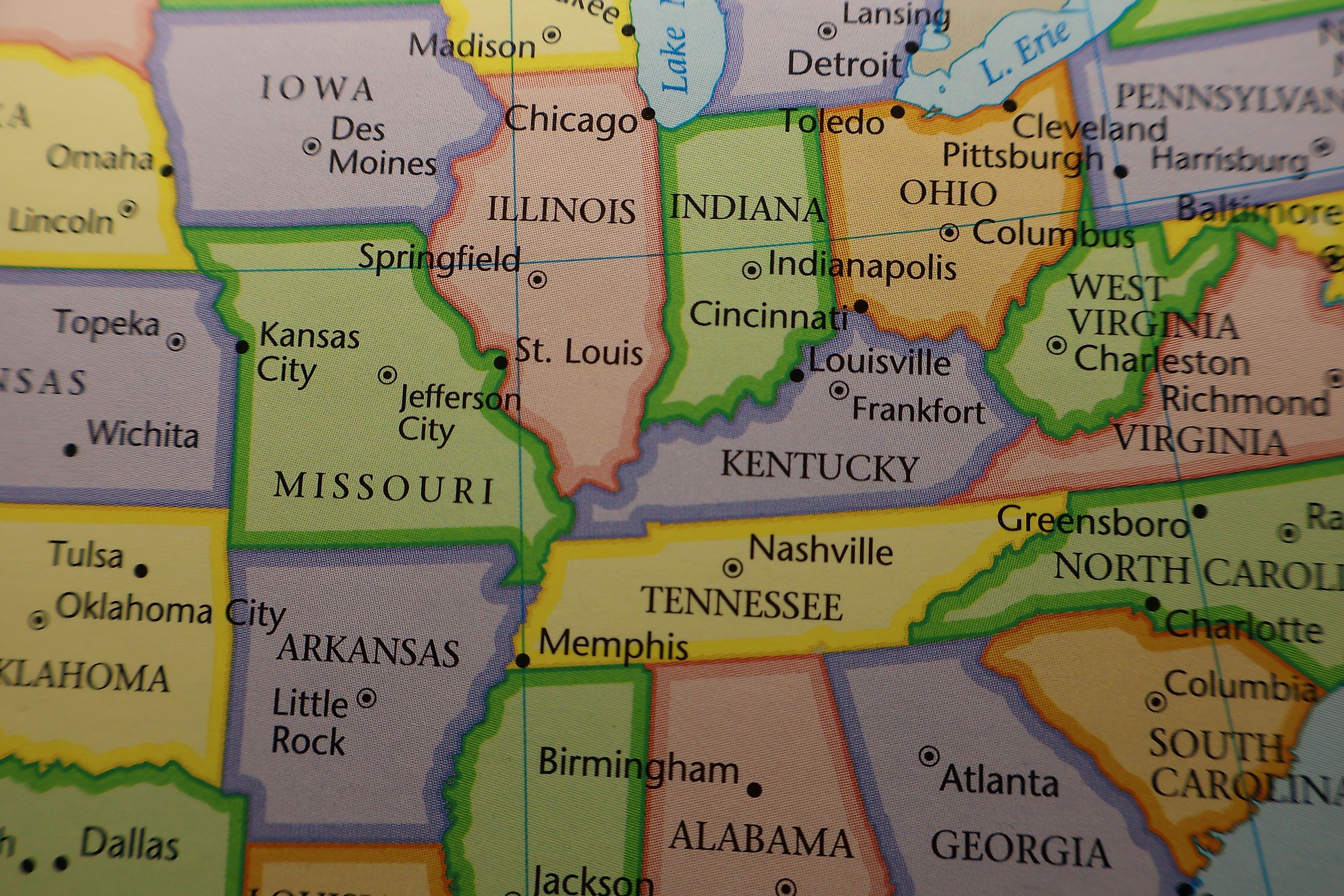
At its core, the Corn Belt spans the central Midwest. Its boundaries shift depending on how production is measured, but a small group of states appears in nearly every definition of the region.
Iowa

Iowa leads the nation in corn production by a wide margin. Corn covers more acreage here than any other crop, with around 13 million acres planted each year. Yields rank among the highest in the world. The state’s rolling plains rest on some of the richest topsoil on Earth, built over centuries by prairie grasses and glacial deposits.
Corn and soybeans dominate nearly every county. Livestock feeding, ethanol production, and grain processing form a tight economic loop that supports rural towns and export markets. In many ways, Iowa represents the Corn Belt at its purest.
Illinois

Illinois rivals Iowa in both output and influence, sitting at the center of corn country in a very literal way. Central and northern Illinois rely on flat ground and deep prairie soils that give steady, high-volume harvests year after year. Corn and soybeans are rotated to keep soil rich and yields strong.
Roughly 11 million acres of Illinois farmland go to corn each season. That scale feeds a massive network of grain elevators, ethanol plants, feed operations, and export routes that move crops toward the Mississippi River and Great Lakes.
History plays a role too. Early adoption of modern farming tools, dense rail networks, and access to major waterways turned Illinois into a hub for large-scale grain production long before corn became a global commodity. Today, strong demand keeps Illinois firmly at the core of the Corn Belt.
Nebraska

Nebraska covers about 9 to 10 million acres of corn in strong planting years, feeding one of the country’s largest livestock industries. Feedlots rely heavily on nearby corn, keeping grain production and cattle closely connected.
Eastern Nebraska follows the classic Midwestern pattern with fertile soils and rain-fed fields similar to Iowa. Farther west, drier conditions require irrigation, and center-pivot systems drawing from the Ogallala Aquifer transform the plains into highly productive cornland.
Modern technology drives production across the state. Drought-tolerant hybrids, precision farming, and advanced irrigation methods help corn thrive even where natural rainfall falls short.
Minnesota

Southern Minnesota marks the northern edge of the Corn Belt. Long summer days and fertile soils help corn grow quick and strong, even though cold winters shorten the growing season. Modern corn hybrids give farmers the flexibility to get the most out of each season.
Corn is a key part of the state’s agricultural economy, closely tied to soybeans and livestock feeding operations. Grain elevators, feedlots, and local processing facilities all depend on these crops.
Northern Minnesota shifts away from large-scale row crops, marking a clear transition out of Corn Belt territory.
Indiana

Indiana sits at the heart of the Corn Belt, with central and northern counties producing massive amounts of corn. In strong years, farmers plant around 5 to 6 million acres. Fertile soils and steady rainfall help crops grow reliably, and rotating fields between corn and soybeans keeps the soil healthy and yields strong.
Corn drives much of the state’s agricultural economy. Highways and railways carry the harvest to ethanol plants, livestock farms, and food processors. That network links rural towns to both domestic and global markets, making Indiana a major contributor to the Corn Belt’s output.
Ohio

Ohio forms the eastern edge of the Corn Belt. Western and central counties grow large volumes of corn each year on rich glacial soils and in favorable climate conditions. Hills and mixed farms appear in the eastern part of the state, showing a clear change in landscape and land use.
Corn is one of Ohio’s top crops and fuels both livestock feed and ethanol production. The state shows how the Corn Belt blends into other farming regions, with production tapering off instead of stopping suddenly.
Missouri

Missouri often sparks debate when defining the Corn Belt. Northern counties clearly fall into corn country, with fertile soils and climate patterns that produce strong yields year after year. Corn covers almost 4 million acres here, frequently rotated with soybeans to protect soil health.
Southern Missouri takes on a different character. Rolling hills and warmer, drier conditions favor pasture, hay, and a mix of crops instead of large-scale corn production. That transition shows how the Corn Belt isn’t a strict line on a map but a gradient shaped by soil, climate, and farming practices.
Kansas

Kansas plays a major role in US corn production, even if it looks different from the classic Corn Belt. Eastern Kansas grows rain-fed corn on fertile soils, producing yields that compete with more central states. As you move west, rainfall drops, and irrigation from underground aquifers becomes essential. Center-pivot systems and advanced water management make large-scale corn farming possible in these drier areas.
Corn in Kansas fuels one of the nation’s biggest cattle feeding operations. Feedlots across the state rely on locally grown corn for cattle diets. The crop also supports ethanol plants, turning part of the harvest into biofuel for domestic use and export.
Kansas sits at a transitional edge. Corn competes with wheat and sorghum, especially in the western and southwestern regions. Farmers adapt their rotations to balance water availability, soil types, and market demand. That flexibility allows Kansas to produce impressive corn volumes without fully fitting the stereotypical Corn Belt mold.
South Dakota

South Dakota has become an increasingly important corn producer in recent decades. Eastern counties grow corn on rich glacial soils similar to those in Iowa and Minnesota. In good years, planting covers around 6 million acres. Steady summer rainfall and long daylight hours support healthy crops, and farmers use modern hybrids and precision planting techniques to maximize output.
As you move west, corn gives way to ranching, wheat, and other dryland crops where rainfall is lighter. Despite that, the state’s overall corn production continues to rise, contributing to livestock feed, ethanol plants, and export markets.
States Left Out of the Corn Belt

Several states produce large amounts of corn without being considered part of the Corn Belt.
-
Wisconsin focuses heavily on dairy, though corn supports feed needs.
-
Michigan grows corn alongside fruit and specialty crops.
-
Kentucky produces corn but leans toward livestock and tobacco history.
-
Texas grows corn primarily through irrigation rather than Midwest-style rain-fed systems.
These states contribute meaningfully to corn supply but fall outside the classic Corn Belt framework.
America’s Corn Core
Corn drives more than farmland. It sets the pace for rural towns, guides seasonal rhythms, and powers local economies. Harvest season affects school calendars, equipment sales, and transport across the Midwest.
The crop feeds the nation in countless ways. Sweeteners, cooking oils, animal feed, and fuel all start in Corn Belt fields. Its impact reaches far beyond farms, quietly connecting to daily life across the country.
The Corn Belt ranks among the world’s most productive agricultural regions. Its output supports food security, renewable energy, and trade. As technology and markets evolve, this heart of American agriculture continues to play a vital role.
| State | Primary Corn Regions | Corn Acreage (Millions) |
|---|---|---|
| Iowa | Central, Northern, Southern | ~13 |
| Illinois | Central, Northern | ~11 |
| Nebraska | Eastern (rain-fed), Western (irrigated) | 9 to 10 |
| Minnesota | Southern, Central | ~8 |
| Indiana | Central, Northern | 5 to 6 |
| Ohio | Western, Central | ~3 |
| Missouri | Northern | ~3.8 |
| Kansas | Eastern (rain-fed), Western (irrigated) | ~6 |
| South Dakota | Eastern | ~6 |